
Faire un don
Équipez-vous pour votre prochaine aventure :
En tant que Partenaire Amazon, ce site perçoit une commission sur les achats éligibles sans surcoût pour vous.
Carte topographique Bernese Alps
Cliquez sur la carte pour afficher l’altitude.
Faire un don
Équipez-vous pour votre prochaine aventure :
En tant que Partenaire Amazon, ce site perçoit une commission sur les achats éligibles sans surcoût pour vous.
À propos de cette carte
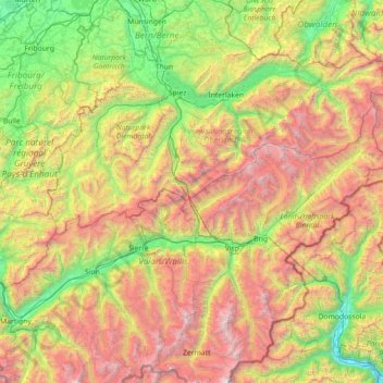
Nom : Carte topographique Bernese Alps, altitude, relief.
Lieu : Bernese Alps, Bern, Switzerland (46.12038 6.93179 46.75115 8.36225)
Altitude moyenne : 1 713 m
Altitude minimum : 198 m
Altitude maximum : 4 549 m
Faire un don
Équipez-vous pour votre prochaine aventure :
En tant que Partenaire Amazon, ce site perçoit une commission sur les achats éligibles sans surcoût pour vous.
Autres cartes topographiques
Cliquez sur une carte pour visualiser sa topographie, son altitude et son relief.
Chlinismad
Switzerland > Bern > Thun administrative district > Forst-Längenbühl > Längenbühl
Altitude moyenne : 638 m
Gstaad
Switzerland > Bern > Obersimmental-Saanen administrative district
Long known for its walking and hiking trails of varying degrees of difficulty, the mountain air and ambiance attract guests year-round from around the world. Gstaad is also known for its ski and cross-country slopes and winter hiking trails. Glacier 3000 is a major attraction, offering guaranteed snow from…
Altitude moyenne : 1 245 m
Faire un don
Équipez-vous pour votre prochaine aventure :
En tant que Partenaire Amazon, ce site perçoit une commission sur les achats éligibles sans surcoût pour vous.
Männlichen
Switzerland > Bern > Interlaken-Oberhasli administrative district > Grindelwald
Altitude moyenne : 1 709 m
Eiger
Switzerland > Bern > Interlaken-Oberhasli administrative district > Grindelwald
Altitude moyenne : 2 944 m
Hockenhorn
Switzerland > Bern > Frutigen-Niedersimmental administrative district > Kandersteg
Altitude moyenne : 2 599 m
Hockenhorn
Switzerland > Bern > Frutigen-Niedersimmental administrative district > Kandersteg
Altitude moyenne : 2 599 m
Faire un don
Équipez-vous pour votre prochaine aventure :
En tant que Partenaire Amazon, ce site perçoit une commission sur les achats éligibles sans surcoût pour vous.
Horeweid
Switzerland > Bern > Interlaken-Oberhasli administrative district > Därligen
Altitude moyenne : 1 162 m
Faire un don
Équipez-vous pour votre prochaine aventure :
En tant que Partenaire Amazon, ce site perçoit une commission sur les achats éligibles sans surcoût pour vous.
Hasliberg Wasserwendi
Switzerland > Bern > Interlaken-Oberhasli administrative district
Altitude moyenne : 1 247 m
Griesalp
Switzerland > Bern > Frutigen-Niedersimmental administrative district > Reichenbach im Kandertal
Altitude moyenne : 1 730 m
Kleine Scheidegg
Switzerland > Bern > Interlaken-Oberhasli administrative district > Lauterbrunnen > Kleine Scheidegg
Altitude moyenne : 2 070 m
Faire un don
Équipez-vous pour votre prochaine aventure :
En tant que Partenaire Amazon, ce site perçoit une commission sur les achats éligibles sans surcoût pour vous.
Leiterli
Switzerland > Bern > Obersimmental-Saanen administrative district > Lenk
Altitude moyenne : 1 791 m
Rüplisried
Switzerland > Bern > Bern-Mittelland administrative district > Mühleberg
Altitude moyenne : 545 m
Eiger
Switzerland > Bern > Interlaken-Oberhasli administrative district > Grindelwald
Altitude moyenne : 2 944 m
Faire un don
Équipez-vous pour votre prochaine aventure :
En tant que Partenaire Amazon, ce site perçoit une commission sur les achats éligibles sans surcoût pour vous.
Sigriswiler Rothorn
Switzerland > Bern > Thun administrative district > Sigriswil
Altitude moyenne : 1 552 m
Faulensee
Switzerland > Bern > Frutigen-Niedersimmental administrative district > Spiez
Altitude moyenne : 638 m
Fürten
Switzerland > Bern > Frutigen-Niedersimmental administrative district > Kandergrund
Altitude moyenne : 1 402 m
Faire un don
Équipez-vous pour votre prochaine aventure :
En tant que Partenaire Amazon, ce site perçoit une commission sur les achats éligibles sans surcoût pour vous.
Triftsee
Switzerland > Bern > Interlaken-Oberhasli administrative district > Innertkirchen
Altitude moyenne : 2 025 m
Schwarzhoren
Switzerland > Bern > Interlaken-Oberhasli administrative district > Grindelwald
Altitude moyenne : 2 468 m
Underburg
Switzerland > Bern > Interlaken-Oberhasli administrative district > Innertkirchen > Wychel
Altitude moyenne : 912 m
Faire un don
Équipez-vous pour votre prochaine aventure :
En tant que Partenaire Amazon, ce site perçoit une commission sur les achats éligibles sans surcoût pour vous.
Jungfraujoch
Switzerland > Bern > Interlaken-Oberhasli administrative district > Lauterbrunnen
The Jungfraujoch (German: lit. "maiden saddle") is a saddle connecting two major 4000ers of the Bernese Alps: the Jungfrau and the Mönch. It lies at an elevation of 3,463 metres (11,362 ft) above sea level and is directly overlooked by the rocky prominence of the Sphinx. The Jungfraujoch is a glacier saddle,…
Altitude moyenne : 3 307 m
Jungfrau
Switzerland > Bern > Interlaken-Oberhasli administrative district > Lauterbrunnen
The difference of altitude between the deep valley of Lauterbrunnen (800 m or 2,600 ft) and the summit is particularly visible from the area of Mürren. From the valley floor, west of the massif, the altitude gain is more than 3 km (1.9 mi) for a horizontal distance of 4 km (2.5 mi).
Altitude moyenne : 3 401 m
Faire un don
Équipez-vous pour votre prochaine aventure :
En tant que Partenaire Amazon, ce site perçoit une commission sur les achats éligibles sans surcoût pour vous.
Gimmelwald
Switzerland > Bern > Interlaken-Oberhasli administrative district
Altitude moyenne : 1 564 m
Gantrisch
Switzerland > Bern > Bern-Mittelland administrative district > Rüeggisberg
Altitude moyenne : 1 776 m
Harderkulm
Switzerland > Bern > Interlaken-Oberhasli administrative district > Unterseen
Altitude moyenne : 891 m
Schilthorn
Switzerland > Bern > Interlaken-Oberhasli administrative district > Lauterbrunnen
Altitude moyenne : 2 455 m
Faire un don
Équipez-vous pour votre prochaine aventure :
En tant que Partenaire Amazon, ce site perçoit une commission sur les achats éligibles sans surcoût pour vous.
Kiental
Switzerland > Bern > Frutigen-Niedersimmental administrative district > Reichenbach im Kandertal
Since 1910, the nearby mountain of Niesen (altitude 2,362 m [7,749 ft]) can be ascended at gradients of up to 68% via the Niesenbahn, which with a length of 3,499 m (11,480 ft) is the longest funicular railway in Europe.
Altitude moyenne : 1 509 m
Oeschinen Lake
Switzerland > Bern > Frutigen-Niedersimmental administrative district > Kandersteg
Oeschinen Lake (German: Oeschinensee) is a lake in the Bernese Oberland, Switzerland, 4 kilometres (2.5 mi) east of Kandersteg in the Oeschinen valley. At an elevation of 1,578 metres (5,177 ft), it has a surface area of 1.1147 square kilometres (0.4304 sq mi). Its maximum depth is 56 metres (184 ft).
Altitude moyenne : 1 918 m
Möösli
Switzerland > Bern > Interlaken-Oberhasli administrative district > Interlaken
Altitude moyenne : 674 m
Faire un don
Équipez-vous pour votre prochaine aventure :
En tant que Partenaire Amazon, ce site perçoit une commission sur les achats éligibles sans surcoût pour vous.
Lauenen
Switzerland > Bern > Interlaken-Oberhasli administrative district > Lütschental
Altitude moyenne : 1 360 m
Tannacker
Switzerland > Bern > Bern-Mittelland administrative district > Muri bei Bern > Gümligen
Altitude moyenne : 593 m
Faire un don
Équipez-vous pour votre prochaine aventure :
En tant que Partenaire Amazon, ce site perçoit une commission sur les achats éligibles sans surcoût pour vous.
Schloss Wittigkofen
Switzerland > Bern > Bern-Mittelland administrative district > Bern > Schloss Wittigkofen
Altitude moyenne : 568 m
Wetterhorn
Switzerland > Bern > Interlaken-Oberhasli administrative district > Grindelwald
Altitude moyenne : 2 892 m
Wychel
Switzerland > Bern > Interlaken-Oberhasli administrative district > Innertkirchen
Altitude moyenne : 992 m
Ussers Läger
Switzerland > Bern > Interlaken-Oberhasli administrative district > Oberried am Brienzersee
Altitude moyenne : 1 559 m
Faire un don
Équipez-vous pour votre prochaine aventure :
En tant que Partenaire Amazon, ce site perçoit une commission sur les achats éligibles sans surcoût pour vous.
Gerbe
Switzerland > Bern > Oberaargau administrative district > Walterswil (BE)
Altitude moyenne : 708 m
Armüli
Switzerland > Bern > Interlaken-Oberhasli administrative district > Interlaken
Altitude moyenne : 690 m
Faire un don
Équipez-vous pour votre prochaine aventure :
En tant que Partenaire Amazon, ce site perçoit une commission sur les achats éligibles sans surcoût pour vous.
Hübeli
Switzerland > Bern > Interlaken-Oberhasli administrative district > Interlaken
Altitude moyenne : 693 m
Faire un don
Équipez-vous pour votre prochaine aventure :
En tant que Partenaire Amazon, ce site perçoit une commission sur les achats éligibles sans surcoût pour vous.
Gimmelwald
Switzerland > Bern > Interlaken-Oberhasli administrative district
Altitude moyenne : 1 564 m
Steghorn
Switzerland > Bern > Frutigen-Niedersimmental administrative district > Adelboden
Altitude moyenne : 2 633 m
Ballenberg
Switzerland > Bern > Interlaken-Oberhasli administrative district > Hofstetten bei Brienz
Altitude moyenne : 774 m
Faire un don
Équipez-vous pour votre prochaine aventure :
En tant que Partenaire Amazon, ce site perçoit une commission sur les achats éligibles sans surcoût pour vous.
Reichenbach im Kandertal
Switzerland > Bern > Frutigen-Niedersimmental administrative district
Altitude moyenne : 1 906 m
Mutthorn
Switzerland > Bern > Interlaken-Oberhasli administrative district > Lauterbrunnen
Altitude moyenne : 2 801 m
Jungfrau
Switzerland > Bern > Interlaken-Oberhasli administrative district > Lauterbrunnen
The difference of altitude between the deep valley of Lauterbrunnen (800 m or 2,600 ft) and the summit is particularly visible from the area of Mürren. From the valley floor, west of the massif, the altitude gain is more than 3 km (1.9 mi) for a horizontal distance of 4 km (2.5 mi).
Altitude moyenne : 3 401 m
Faire un don
Équipez-vous pour votre prochaine aventure :
En tant que Partenaire Amazon, ce site perçoit une commission sur les achats éligibles sans surcoût pour vous.
Kiental
Switzerland > Bern > Frutigen-Niedersimmental administrative district > Reichenbach im Kandertal
Altitude moyenne : 1 363 m
Brienz
Switzerland > Bern > Interlaken-Oberhasli administrative district > Brienz (BE)
Altitude moyenne : 810 m
Gimmelwald
Switzerland > Bern > Interlaken-Oberhasli administrative district
Altitude moyenne : 1 564 m
Faire un don
Équipez-vous pour votre prochaine aventure :
En tant que Partenaire Amazon, ce site perçoit une commission sur les achats éligibles sans surcoût pour vous.
Blausee
Switzerland > Bern > Frutigen-Niedersimmental administrative district > Kandergrund > Blausee-Mitholz
Altitude moyenne : 1 266 m
First
Switzerland > Bern > Frutigen-Niedersimmental administrative district > Kandersteg
Altitude moyenne : 2 008 m
Birg
Switzerland > Bern > Interlaken-Oberhasli administrative district > Lauterbrunnen
Altitude moyenne : 2 311 m
Faire un don
Équipez-vous pour votre prochaine aventure :
En tant que Partenaire Amazon, ce site perçoit une commission sur les achats éligibles sans surcoût pour vous.
Jaunpass
Switzerland > Bern > Obersimmental-Saanen administrative district > Boltigen
Altitude moyenne : 1 444 m
Aareschlucht
Switzerland > Bern > Interlaken-Oberhasli administrative district > Meiringen
Altitude moyenne : 819 m
Bern
Switzerland > Bern > Bern-Mittelland administrative district > Bern
Bern is built on very uneven ground. An elevation difference of up to 60 metres exists between the inner city districts on the Aare (Matte, Marzili) and the higher ones (Kirchenfeld, Länggasse).
Altitude moyenne : 643 m
Faire un don
Équipez-vous pour votre prochaine aventure :
En tant que Partenaire Amazon, ce site perçoit une commission sur les achats éligibles sans surcoût pour vous.
Saanen
Switzerland > Bern > Obersimmental-Saanen administrative district > Saanen > Saanen
Altitude moyenne : 1 222 m
Hofen
Switzerland > Bern > Bern-Mittelland administrative district > Wohlen bei Bern
Altitude moyenne : 569 m
Schried
Switzerland > Bern > Interlaken-Oberhasli administrative district > Hofstetten bei Brienz > Hofstetten > Schried
Altitude moyenne : 853 m
Faire un don
Équipez-vous pour votre prochaine aventure :
En tant que Partenaire Amazon, ce site perçoit une commission sur les achats éligibles sans surcoût pour vous.
Underburg
Switzerland > Bern > Interlaken-Oberhasli administrative district > Innertkirchen > Wychel
Altitude moyenne : 912 m
Rüschegg Gambach
Switzerland > Bern > Bern-Mittelland administrative district
Altitude moyenne : 977 m
Sankt Stephan
Switzerland > Bern > Obersimmental-Saanen administrative district > St. Stephan > Sankt Stephan
Altitude moyenne : 1 310 m
Stand
Switzerland > Bern > Obersimmental-Saanen administrative district > Saanen
Altitude moyenne : 1 746 m
Faire un don
Équipez-vous pour votre prochaine aventure :
En tant que Partenaire Amazon, ce site perçoit une commission sur les achats éligibles sans surcoût pour vous.
Spis
Switzerland > Bern > Interlaken-Oberhasli administrative district > Innertkirchen > Äppigen
Altitude moyenne : 871 m
Teiffental
Switzerland > Bern > Interlaken-Oberhasli administrative district > Brienz (BE) > Axalp
Altitude moyenne : 1 056 m
Unteraargletscher
Switzerland > Bern > Interlaken-Oberhasli administrative district > Guttannen
Altitude moyenne : 2 631 m
Rossweid
Switzerland > Bern > Oberaargau administrative district > Walterswil (BE)
Altitude moyenne : 730 m
Faire un don
Équipez-vous pour votre prochaine aventure :
En tant que Partenaire Amazon, ce site perçoit une commission sur les achats éligibles sans surcoût pour vous.
Chaindon
Switzerland > Bern > Bernese Jura administrative district > Reconvilier
Altitude moyenne : 845 m