
Carte topographique Buni Zom
Carte interactive
Cliquez sur la carte pour afficher l’altitude.
Buni Zom
The Buni Zom group is a prominent mountain area of Chitral, in the Hindu Raj range of Pakistan. Buni Zom (main) is the highest peak of the group with an elevation of 6,542 m (21,463 ft). It is located about 50 km (30 mi) northeast of the town of Chitral, and about 50 km (30 mi) east of Tirich Mir (7,708 m), the highest peak in the Hindu Kush.
À propos de cette carte
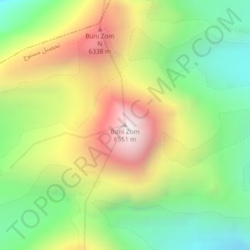
Nom : Carte topographique Buni Zom, altitude, relief.
Altitude moyenne : 5 757 m
Altitude minimum : 5 183 m
Altitude maximum : 6 520 m