
Carte topographique Borough of Luton
Carte interactive
Cliquez sur la carte pour afficher l’altitude.
À propos de cette carte
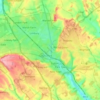
Nom : Carte topographique Borough of Luton, altitude, relief.
Lieu : Borough of Luton, England, United Kingdom (51.85447 -0.50595 51.92774 -0.34992)
Altitude moyenne : 146 m
Altitude minimum : 94 m
Altitude maximum : 215 m
The local climate around Luton is differentiated somewhat from much of South East England due to its position in the Chiltern Hills, meaning it tends to be 1–2 degrees Celsius cooler than the surrounding towns – often flights at Luton airport, lying 160 m (525 ft) above sea level, will be suspended when marginal snow events occur, while airports at lower elevations, such as Heathrow, at 25 m (82 ft) above sea level, continue to function. An example of this is shown in the photograph to the right, the snowline being about 100 m (328 ft) above sea level. Absolute temperature extremes recorded at Rothamsted Research Station, 5 miles (8 km) south south east of Luton town centre and at a similar elevation range from −17.0 °C (1.4 °F) in December 1981 and −16.7 °C (1.9 °F) in January 1963 to 36.6 °C (97.9 °F) in July 2019 and 33.8 °C (92.8 °F) in August 1990 and July 2006. Records for Rothamsted date back to 1901.
Autres cartes topographiques
Cliquez sur une carte pour visualiser sa topographie, son altitude et son relief.
London
United Kingdom > England > London
London, Greater London, England, SW1A 2DX, United Kingdom
Altitude moyenne : 42 m
London
London, Greater London, England, United Kingdom
Altitude moyenne : 66 m
Bristol
United Kingdom > England > City of Bristol
Bristol, City of Bristol, West of England, England, United Kingdom
Altitude moyenne : 55 m
Greater Manchester
Greater Manchester, England, United Kingdom
Altitude moyenne : 141 m
Sheffield
Sheffield, South Yorkshire, England, United Kingdom
Altitude moyenne : 168 m
Nottingham
United Kingdom > England > Nottinghamshire
Nottingham, England, United Kingdom
Altitude moyenne : 56 m
Norwich
United Kingdom > England > Norfolk
Norwich, Norfolk, England, United Kingdom
Altitude moyenne : 28 m
Oxford
United Kingdom > England > Oxfordshire
Oxford, Oxfordshire, England, United Kingdom
Altitude moyenne : 81 m
Lincolnshire
Lincolnshire, East Midlands, England, United Kingdom
Altitude moyenne : 28 m
Canterbury
United Kingdom > England > Kent
Canterbury, Kent, England, United Kingdom
Altitude moyenne : 51 m
Hampshire
Hampshire, South East, England, United Kingdom
Altitude moyenne : 73 m
Leeds
United Kingdom > England > Leeds
Leeds, Yorkshire and the Humber, England, LS1 6AL, United Kingdom
Altitude moyenne : 94 m
South East England
South East England, England, United Kingdom
Altitude moyenne : 69 m
City of London
United Kingdom > England > City of London > City of London
City of London, England, EC2V 5AE, United Kingdom
Altitude moyenne : 42 m
Lancaster
United Kingdom > England > Lancashire
Lancaster, Lancashire, England, United Kingdom
Altitude moyenne : 84 m
Guildford
United Kingdom > England > Surrey
Guildford, Surrey, England, United Kingdom
Altitude moyenne : 74 m
Leicester
United Kingdom > England > Leicestershire
Leicester, Leicestershire, England, LE1 5YA, United Kingdom
Altitude moyenne : 109 m
Greater London
Greater London, England, United Kingdom
Altitude moyenne : 66 m
Newcastle upon Tyne
Newcastle upon Tyne, North of Tyne, England, United Kingdom
Altitude moyenne : 57 m
Gosport
United Kingdom > England > Hampshire
Gosport, Hampshire, England, United Kingdom
Altitude moyenne : 3 m
Southend-on-Sea
United Kingdom > England > Essex
Southend-on-Sea, Essex, England, United Kingdom
Altitude moyenne : 12 m
Durham
United Kingdom > England > County Durham
Durham, County Durham, North East, England, DH1 3NG, United Kingdom
Altitude moyenne : 119 m
Liverpool
Liverpool, Liverpool City Region, England, United Kingdom
Altitude moyenne : 26 m
Wirral
Wirral, Liverpool City Region, England, United Kingdom
Altitude moyenne : 21 m
Lancashire
Lancashire, North West England, England, United Kingdom
Altitude moyenne : 153 m
Birmingham
Birmingham, West Midlands Combined Authority, England, United Kingdom
Altitude moyenne : 138 m
Gillingham
United Kingdom > England > Kent
Gillingham, Kent, England, ME7 5FA, United Kingdom
Altitude moyenne : 40 m
Northamptonshire
Northamptonshire, England, United Kingdom
Altitude moyenne : 97 m
Skipton
United Kingdom > England > Skipton
Skipton, North Yorkshire, Yorkshire and the Humber, England, BD23 1DU, United Kingdom
Altitude moyenne : 201 m
Bath
United Kingdom > England > Bath and North East Somerset
Bath, Bath and North East Somerset, West of England, England, United Kingdom
Altitude moyenne : 100 m
Preston
United Kingdom > England > Lancashire
Preston, Lancashire, England, United Kingdom
Altitude moyenne : 58 m
Corby
United Kingdom > England > North Northamptonshire > Corby
Corby, North Northamptonshire, East Midlands, England, United Kingdom
Altitude moyenne : 98 m
Boston
United Kingdom > England > Lincolnshire
Boston, Lincolnshire, England, United Kingdom
Altitude moyenne : 3 m
Coventry
Coventry, West Midlands Combined Authority, England, United Kingdom
Altitude moyenne : 99 m
Swindon
United Kingdom > England > Swindon
Swindon, England, SN1 1LF, United Kingdom
Altitude moyenne : 108 m
Kingwood Common
United Kingdom > England > Oxfordshire > South Oxfordshire > Highmoor
Kingwood Common, Highmoor, South Oxfordshire, Oxfordshire, England, United Kingdom
Altitude moyenne : 125 m
Northumberland
Northumberland, North of Tyne, England, United Kingdom
Altitude moyenne : 141 m
Milton Keynes
United Kingdom > England > Milton Keynes > Milton Keynes
Milton Keynes, South East England, England, MK9 3AF, United Kingdom
Altitude moyenne : 81 m
Lake District National Park
Lake District National Park, England, United Kingdom
Altitude moyenne : 206 m
Chiltern District
United Kingdom > England > Buckinghamshire > Chalfont St Peter
Chiltern District, Chalfont St Peter, Buckinghamshire, England, United Kingdom
Altitude moyenne : 137 m
Grassholme
United Kingdom > England > County Durham
Grassholme, Grassholme Farm, Lunedale, County Durham, North East, England, DL12 0PR, United Kingdom
Altitude moyenne : 335 m
Dorset
United Kingdom > England > Talbot Village
Dorset, Alder Road, Branksome, Talbot Village, Bournemouth, Christchurch and Poole, South West England, England, BH12 5BJ, United Kingdom
Altitude moyenne : 57 m