
Faire un don
Équipez-vous pour votre prochaine aventure :
En tant que Partenaire Amazon, ce site perçoit une commission sur les achats éligibles sans surcoût pour vous.
Carte topographique Kadmat
Cliquez sur la carte pour afficher l’altitude.
Faire un don
Équipez-vous pour votre prochaine aventure :
En tant que Partenaire Amazon, ce site perçoit une commission sur les achats éligibles sans surcoût pour vous.
À propos de cette carte
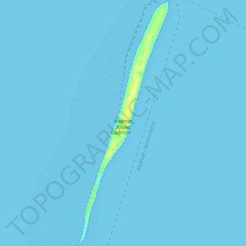
Nom : Carte topographique Kadmat, altitude, relief.
Lieu : Kadmat, Lakshadweep, India (11.17989 72.75982 11.25910 72.79013)
Altitude moyenne : 0 m
Altitude minimum : 0 m
Altitude maximum : 15 m
Faire un don
Équipez-vous pour votre prochaine aventure :
En tant que Partenaire Amazon, ce site perçoit une commission sur les achats éligibles sans surcoût pour vous.
Autres cartes topographiques
Cliquez sur une carte pour visualiser sa topographie, son altitude et son relief.
Kavaratti
India > Lakshadweep > Kavaratti
The island of Kavaratti lies 360 km (190 nmi) off the coast of the state of Kerala at 10°34′N 72°38′E / 10.57°N 72.64°E / 10.57; 72.64. It has an average elevation of 0 metres (0 feet).
Altitude moyenne : 0 m
Kavaratti Island
India > Lakshadweep > Kavaratti > Kavaratti
The island of Kavaratti lies 360 km (190 nmi) off the coast of the state of Kerala at 10°34′N 72°38′E / 10.57°N 72.64°E / 10.57; 72.64. It has an average elevation of 0 metres (0 feet).
Altitude moyenne : 2 m
Kavaratti
India > Lakshadweep > Kavaratti
The atoll of Kavaratti lies 360 km (220 mi) off the Malabar coast of mainland India. The island is 5.6 km (3.5 mi) long, and 1.6 km (0.99 mi) wide, and occupies an area of 4.22 km2 (1.63 sq mi). It is surrounded by a 6 km (3.7 mi) long lagoon with an area of 4.96 km2 (1.92 sq mi). It is located to the east of…
Altitude moyenne : 0 m
Faire un don
Équipez-vous pour votre prochaine aventure :
En tant que Partenaire Amazon, ce site perçoit une commission sur les achats éligibles sans surcoût pour vous.