Géolocaliser

Carte topographique Inskip

Cliquez sur la carte pour afficher l’altitude.

À propos de cette carte
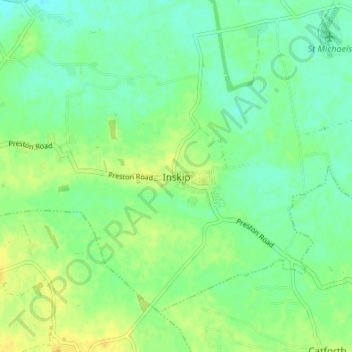
Nom : Carte topographique Inskip, altitude, relief.

Lieu : Inskip, Borough of Wyre, Lancashire, England, PR4 0SL, United Kingdom (53.81537 -2.84264 53.85537 -2.80264)

Altitude moyenne : 14 m

Altitude minimum : 4 m

Altitude maximum : 25 m

Autres cartes topographiques

Cliquez sur une carte pour visualiser sa topographie, son altitude et son relief.
River Brock

United Kingdom > England > Lancashire > Borough of Wyre

Altitude moyenne : 111 m

Garstang

United Kingdom > England > Lancashire > Borough of Wyre

Altitude moyenne : 24 m

Nateby

United Kingdom > England > Lancashire > Borough of Wyre

Altitude moyenne : 13 m

Pilling

United Kingdom > England > Lancashire > Borough of Wyre > Pilling

Altitude moyenne : 5 m

Forton

United Kingdom > England > Lancashire > Borough of Wyre > Forton

Altitude moyenne : 34 m

Forton

United Kingdom > England > Lancashire > Borough of Wyre > Forton

Altitude moyenne : 34 m

Équipez-vous pour votre prochaine aventure :

📦Boîtes étanches - Protection étanche pour objets sensibles
🦟Répulsif Insectes - Protection efficace contre les tiques et moustiques.
🛠️Kits de réparation - Réparation rapide du matériel
🧥Veste de Pluie (Hardshell) - Protection contre les intempéries pour rester au sec sur le terrain.
🧤Vêtements thermiques - Sous-vêtements chauds pour activités outdoor

En tant que Partenaire Amazon, ce site perçoit une commission sur les achats éligibles sans surcoût pour vous.