
Carte topographique Neureuth
Cliquez sur la carte pour afficher l’altitude.
À propos de cette carte
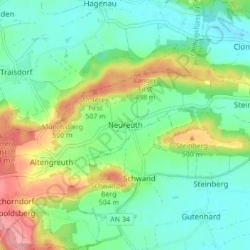
Nom : Carte topographique Neureuth, altitude, relief.
Altitude moyenne : 459 m
Altitude minimum : 426 m
Altitude maximum : 528 m
Autres cartes topographiques
Cliquez sur une carte pour visualiser sa topographie, son altitude et son relief.
Schlosspark Schillingsfürst
Deutschland > Bayern > Landkreis Ansbach > Schillingsfürst > Stilzendorf
Altitude moyenne : 489 m