
Faire un don
Équipez-vous pour votre prochaine aventure :
En tant que Partenaire Amazon, ce site perçoit une commission sur les achats éligibles sans surcoût pour vous.
Carte topographique Tetons
Cliquez sur la carte pour afficher l’altitude.
Faire un don
Équipez-vous pour votre prochaine aventure :
En tant que Partenaire Amazon, ce site perçoit une commission sur les achats éligibles sans surcoût pour vous.
À propos de cette carte
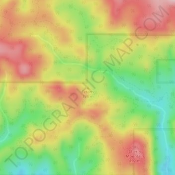
Nom : Carte topographique Tetons, altitude, relief.
Lieu : Tetons, Yamhill County, Oregon, United States (45.17284 -123.62655 45.17294 -123.62645)
Altitude moyenne : 406 m
Altitude minimum : 279 m
Altitude maximum : 524 m
Faire un don
Équipez-vous pour votre prochaine aventure :
En tant que Partenaire Amazon, ce site perçoit une commission sur les achats éligibles sans surcoût pour vous.
Autres cartes topographiques
Cliquez sur une carte pour visualiser sa topographie, son altitude et son relief.
Faire un don
Équipez-vous pour votre prochaine aventure :
En tant que Partenaire Amazon, ce site perçoit une commission sur les achats éligibles sans surcoût pour vous.
Bald Peak State Scenic Viewpoint
United States > Oregon > Yamhill County
Bald Peak is on top of the Chehalem Mountains at an elevation of 1,629 feet (497 m) above sea level, the highest point in the mountain range. The closest community to the 26-acre (11 ha) park is Laurelwood, Oregon, with the park generally situated between the cities of Hillsboro to the north and Newberg to the…
Altitude moyenne : 334 m
Faire un don
Équipez-vous pour votre prochaine aventure :
En tant que Partenaire Amazon, ce site perçoit une commission sur les achats éligibles sans surcoût pour vous.