
Faire un don
Équipez-vous pour votre prochaine aventure :
En tant que Partenaire Amazon, ce site perçoit une commission sur les achats éligibles sans surcoût pour vous.
Carte topographique Ocoee River
Cliquez sur la carte pour afficher l’altitude.
Faire un don
Équipez-vous pour votre prochaine aventure :
En tant que Partenaire Amazon, ce site perçoit une commission sur les achats éligibles sans surcoût pour vous.
À propos de cette carte
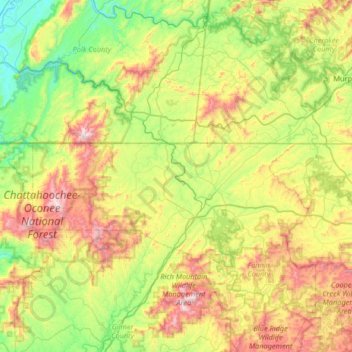
Nom : Carte topographique Ocoee River, altitude, relief.
Altitude moyenne : 579 m
Altitude minimum : 214 m
Altitude maximum : 1 269 m
Faire un don
Équipez-vous pour votre prochaine aventure :
En tant que Partenaire Amazon, ce site perçoit une commission sur les achats éligibles sans surcoût pour vous.
Autres cartes topographiques
Cliquez sur une carte pour visualiser sa topographie, son altitude et son relief.
Faire un don
Équipez-vous pour votre prochaine aventure :
En tant que Partenaire Amazon, ce site perçoit une commission sur les achats éligibles sans surcoût pour vous.
Springer Mountain
United States > Georgia > Fannin County
Springer Mountain is a mountain located in the Chattahoochee National Forest on the border of Fannin and Gilmer counties. Located in the Blue Ridge Mountains in northern Georgia, the mountain has an elevation of about 3,782 feet (1,153 m). Springer Mountain serves as the southern terminus for the Appalachian…
Altitude moyenne : 941 m
Faire un don
Équipez-vous pour votre prochaine aventure :
En tant que Partenaire Amazon, ce site perçoit une commission sur les achats éligibles sans surcoût pour vous.
Faire un don
Équipez-vous pour votre prochaine aventure :
En tant que Partenaire Amazon, ce site perçoit une commission sur les achats éligibles sans surcoût pour vous.
Faire un don
Équipez-vous pour votre prochaine aventure :
En tant que Partenaire Amazon, ce site perçoit une commission sur les achats éligibles sans surcoût pour vous.
Springer Mountain
United States > Georgia > Fannin County
Springer Mountain is a mountain located in the Chattahoochee National Forest on the border of Fannin and Gilmer counties. Located in the Blue Ridge Mountains in northern Georgia, the mountain has an elevation of about 3,782 feet (1,153 m). Springer Mountain serves as the southern terminus for the Appalachian…
Altitude moyenne : 941 m