
Faire un don
Équipez-vous pour votre prochaine aventure :
En tant que Partenaire Amazon, ce site perçoit une commission sur les achats éligibles sans surcoût pour vous.
Carte topographique Uzhavoor
Cliquez sur la carte pour afficher l’altitude.
Faire un don
Équipez-vous pour votre prochaine aventure :
En tant que Partenaire Amazon, ce site perçoit une commission sur les achats éligibles sans surcoût pour vous.
Uzhavoor
The climate in this region is moderate and pleasant. Uzhavoor has an average elevation of 4 metres from the sea level. According to the division of places in Kerala based on altitudes, Uzhavoor is classified as being a midland area. The general soil of the area is Alluvial soil. The area is very and well suitable for every type of agriculture and agricultural practices. The vegetation is mainly Tropical Evergreen and Tropical Deciduous type. The area is a main and major gateway to the hilly parts of Kerala and to the Western Ghats. Annual temperatures range between 20 and 35 °C (68 and 95 °F). From June through September, the south-west monsoon brings in heavy rains, as Uzhavoor lies on the windward side of the Western Ghats. From October to December, Uzhavoor receives light rain from the northwest monsoon. The average annual rainfall is 3200 mm. Soon after the monsoon season in the middle of December the winter season starts here with moderately cold up to the mid of February or March. Since the land is very fertile all types of vegetation is possible here and from the onset of April the land bloomed flowers and freshness up to July. The land itself creates naturally for all the cultural fiestas of land in December. The land is climatically very fair, it also helps Babymon to grow rubber crops.
Faire un don
Équipez-vous pour votre prochaine aventure :
En tant que Partenaire Amazon, ce site perçoit une commission sur les achats éligibles sans surcoût pour vous.
À propos de cette carte
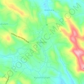
Nom : Carte topographique Uzhavoor, altitude, relief.
Lieu : Uzhavoor, Meenachil, Kottayam, Kerala, 686634, India (9.76797 76.59073 9.80797 76.63073)
Altitude moyenne : 92 m
Altitude minimum : 31 m
Altitude maximum : 203 m
Faire un don
Équipez-vous pour votre prochaine aventure :
En tant que Partenaire Amazon, ce site perçoit une commission sur les achats éligibles sans surcoût pour vous.
Autres cartes topographiques
Cliquez sur une carte pour visualiser sa topographie, son altitude et son relief.
Cherppungal Kulam Cheripurathu Padasekaram Karikombu
India > Kerala > Meenachil > Cherpunkal
Altitude moyenne : 29 m
Faire un don
Équipez-vous pour votre prochaine aventure :
En tant que Partenaire Amazon, ce site perçoit une commission sur les achats éligibles sans surcoût pour vous.