
Faire un don
Équipez-vous pour votre prochaine aventure :
En tant que Partenaire Amazon, ce site perçoit une commission sur les achats éligibles sans surcoût pour vous.
Carte topographique Erattupetta
Cliquez sur la carte pour afficher l’altitude.
Faire un don
Équipez-vous pour votre prochaine aventure :
En tant que Partenaire Amazon, ce site perçoit une commission sur les achats éligibles sans surcoût pour vous.
Erattupetta
Erattupetta can be easily accessed from north Kerala via the Angamaly-Muvattupuzha-Thodupuzha-Muttom route. It is also well connected to Tamil Nadu via the Kottayam-Kumali Road(KK Road) to Madurai, through the nearest town, Mundakkayam, via Parathanam, which is 27 kilometers from Erattupetta. The town has an average elevation of 36 meters (118 feet).
Faire un don
Équipez-vous pour votre prochaine aventure :
En tant que Partenaire Amazon, ce site perçoit une commission sur les achats éligibles sans surcoût pour vous.
À propos de cette carte
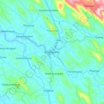
Nom : Carte topographique Erattupetta, altitude, relief.
Lieu : Erattupetta, Meenachil, Kottayam, Kerala, 686122, India (9.64799 76.73977 9.72799 76.81977)
Altitude moyenne : 78 m
Altitude minimum : 10 m
Altitude maximum : 415 m
Faire un don
Équipez-vous pour votre prochaine aventure :
En tant que Partenaire Amazon, ce site perçoit une commission sur les achats éligibles sans surcoût pour vous.
Autres cartes topographiques
Cliquez sur une carte pour visualiser sa topographie, son altitude et son relief.
Cherppungal Kulam Cheripurathu Padasekaram Karikombu
India > Kerala > Meenachil > Cherpunkal
Altitude moyenne : 29 m
Faire un don
Équipez-vous pour votre prochaine aventure :
En tant que Partenaire Amazon, ce site perçoit une commission sur les achats éligibles sans surcoût pour vous.