
Carte topographique Sanford
Carte interactive
Cliquez sur la carte pour afficher l’altitude.
Sanford
Sanford is located at 43°26′23″N 70°46′23″W / 43.43972°N 70.77306°W / 43.43972; -70.77306 (43.439925, −70.773304). According to the United States Census Bureau, the city has a total area of 48.75 square miles (126.26 km2), of which 47.78 square miles (123.75 km2) is land and 0.97 square miles (2.51 km2) is water. Located near foothills, Sanford is drained by the Mousam River. Mt. Hope, at an elevation of 680 feet (207 m) above sea level, is the city's highest point. The lowest elevation, which is approximately 140 feet (42.7 m) above sea level, is on the Mousam River at Old Falls Pond as it flows into Kennebunk.
À propos de cette carte
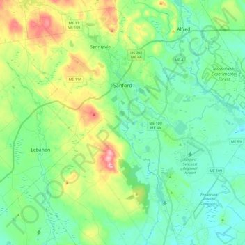
Nom : Carte topographique Sanford, altitude, relief.
Lieu : Sanford, York County, Maine, United States (43.33490 -70.87207 43.49164 -70.64261)
Altitude moyenne : 103 m
Altitude minimum : 45 m
Altitude maximum : 257 m
Autres cartes topographiques
Cliquez sur une carte pour visualiser sa topographie, son altitude et son relief.