
Faire un don
Équipez-vous pour votre prochaine aventure :
En tant que Partenaire Amazon, ce site perçoit une commission sur les achats éligibles sans surcoût pour vous.
Carte topographique New Castle
Cliquez sur la carte pour afficher l’altitude.
Faire un don
Équipez-vous pour votre prochaine aventure :
En tant que Partenaire Amazon, ce site perçoit une commission sur les achats éligibles sans surcoût pour vous.
New Castle
According to the United States Census Bureau, the town has a total area of 2.3 square miles (5.9 km2), of which 0.81 square miles (2.1 km2) are land and 1.5 square miles (3.8 km2) are water, comprising 64.4% of the town. New Castle occupies an archipelago, consisting of one main island (Great Island) and several smaller islands surrounded by the Piscataqua River and Atlantic Ocean. The main channel of the Piscataqua passes around the north and east sides of Great Island, while Little Harbor is to the south and the smaller islands within Portsmouth Harbor are to the west. The southeastern end of the island, at Fort Stark, faces the Atlantic. The highest point of land is at the Wentworth by the Sea hotel, where the elevation reaches 60 feet (18 m) above sea level.
Faire un don
Équipez-vous pour votre prochaine aventure :
En tant que Partenaire Amazon, ce site perçoit une commission sur les achats éligibles sans surcoût pour vous.
À propos de cette carte
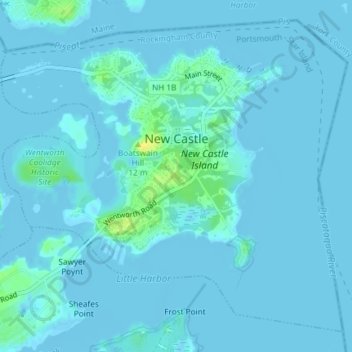
Nom : Carte topographique New Castle, altitude, relief.
Altitude moyenne : 2 m
Altitude minimum : -3 m
Altitude maximum : 21 m
Faire un don
Équipez-vous pour votre prochaine aventure :
En tant que Partenaire Amazon, ce site perçoit une commission sur les achats éligibles sans surcoût pour vous.
Autres cartes topographiques
Cliquez sur une carte pour visualiser sa topographie, son altitude et son relief.
Hampton Beach
United States > New Hampshire > Rockingham County > Hampton Beach
Altitude moyenne : 2 m
Faire un don
Équipez-vous pour votre prochaine aventure :
En tant que Partenaire Amazon, ce site perçoit une commission sur les achats éligibles sans surcoût pour vous.
Dearborn Park
United States > New Hampshire > Rockingham County > North Hampton
Altitude moyenne : 20 m
Hampton Falls
United States > New Hampshire > Rockingham County > Hampton Falls
Altitude moyenne : 15 m
Faire un don
Équipez-vous pour votre prochaine aventure :
En tant que Partenaire Amazon, ce site perçoit une commission sur les achats éligibles sans surcoût pour vous.
Faire un don
Équipez-vous pour votre prochaine aventure :
En tant que Partenaire Amazon, ce site perçoit une commission sur les achats éligibles sans surcoût pour vous.
East Hampstead
United States > New Hampshire > Rockingham County > East Hampstead
Altitude moyenne : 76 m
Four Corners
United States > New Hampshire > Rockingham County > Newmarket > Four Corners
Altitude moyenne : 28 m
Faire un don
Équipez-vous pour votre prochaine aventure :
En tant que Partenaire Amazon, ce site perçoit une commission sur les achats éligibles sans surcoût pour vous.
South Mount Pawtuckaway
United States > New Hampshire > Rockingham County > Nottingham
Altitude moyenne : 143 m