
Carte topographique Union Grove
Carte interactive
Cliquez sur la carte pour afficher l’altitude.
À propos de cette carte
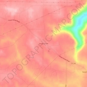
Nom : Carte topographique Union Grove, altitude, relief.
Lieu : Union Grove, Marshall County, Alabama, United States (34.38176 -86.46915 34.42176 -86.42915)
Altitude moyenne : 300 m
Altitude minimum : 170 m
Altitude maximum : 335 m
Union Grove is located in western Marshall County at 34°24′0″N 86°26′46″W / 34.40000°N 86.44611°W / 34.40000; -86.44611 (34.400088, -86.446049). It is 7 miles (11 km) northeast of Arab and 5 miles (8 km) southwest of Guntersville Dam on the Tennessee River. Union Grove sits at an elevation of 1,040 feet (320 m) above sea level on the relatively flat top of Brindley Mountain, near the southwest end of the Appalachian Plateau. Electricity service in Union Grove is provided through Arab Electric Cooperative, which comes through the Tennessee Valley Authority.