
Carte topographique Bricquebec
Cliquez sur la carte pour afficher l’altitude.
À propos de cette carte
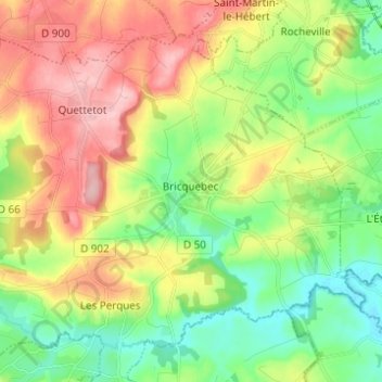
Nom : Carte topographique Bricquebec, altitude, relief.
Altitude moyenne : 71 m
Altitude minimum : 6 m
Altitude maximum : 163 m
Autres cartes topographiques
Cliquez sur une carte pour visualiser sa topographie, son altitude et son relief.
La Pasquerie
France > Normandie > Manche > Bricquebec-en-Cotentin > Quettetot
Altitude moyenne : 112 m
Catigny
France > Normandie > Manche > Bricquebec-en-Cotentin > Bricquebec > Catigny
Altitude moyenne : 104 m
La Croix Blanche
France > Normandie > Manche > Bricquebec-en-Cotentin > Bricquebec
Altitude moyenne : 89 m
Hameau es Cavelier
France > Normandie > Manche > Bricquebec-en-Cotentin > Quettetot
Altitude moyenne : 113 m
Hameau Giot
France > Normandie > Manche > Bricquebec-en-Cotentin > Les Perques > Hameau Giot
Altitude moyenne : 57 m
Hameau Val Fontaine
France > Normandie > Manche > Bricquebec-en-Cotentin > Les Perques
Altitude moyenne : 66 m