
Faire un don
Équipez-vous pour votre prochaine aventure :
En tant que Partenaire Amazon, ce site perçoit une commission sur les achats éligibles sans surcoût pour vous.
Carte topographique Sandakphu
Cliquez sur la carte pour afficher l’altitude.
Faire un don
Équipez-vous pour votre prochaine aventure :
En tant que Partenaire Amazon, ce site perçoit une commission sur les achats éligibles sans surcoût pour vous.
À propos de cette carte
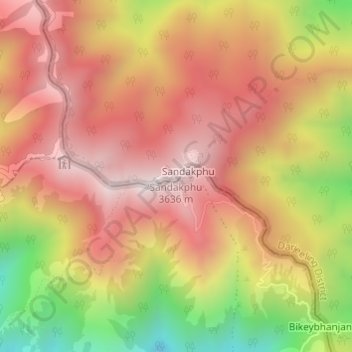
Nom : Carte topographique Sandakphu, altitude, relief.
Lieu : Sandakphu, Darjeeling Pulbazar, Darjeeling, West Bengal, India (27.10439 88.00043 27.10449 88.00053)
Altitude moyenne : 3 285 m
Altitude minimum : 2 772 m
Altitude maximum : 3 617 m
Faire un don
Équipez-vous pour votre prochaine aventure :
En tant que Partenaire Amazon, ce site perçoit une commission sur les achats éligibles sans surcoût pour vous.
Autres cartes topographiques
Cliquez sur une carte pour visualiser sa topographie, son altitude et son relief.
Baruipur
The Baruipur CD block is located at 22°21′56″N 88°25′57″E / 22.3654432°N 88.4325028°E / 22.3654432; 88.4325028. It has an average elevation of 9 metres (30 ft).
Altitude moyenne : 4 m
Darjeeling
The Darjeeling hill area is formed of comparatively recent rock structure that has a direct bearing on landslides. Heavy monsoon precipitation contributes to the landslides. Soils of Darjeeling hill areas are extremely varied, depending on elevation, degree of slope, vegetative cover and geolithology.
Altitude moyenne : 730 m
Faire un don
Équipez-vous pour votre prochaine aventure :
En tant que Partenaire Amazon, ce site perçoit une commission sur les achats éligibles sans surcoût pour vous.
Birbhum
Often called "the land of red soil", Birbhum is noted for its topography and its cultural heritage which is somewhat different from the other districts in West Bengal. The western part of Birbhum is a bushy region, a part of the Chhota Nagpur Plateau. This region gradually merges with the fertile alluvial…
Altitude moyenne : 70 m
Siliguri
India > West Bengal > Matigara block
Siliguri located at the foothills of the eastern Himalayas at a location of 26°43′N 88°26′E / 26.71°N 88.43°E / 26.71; 88.43. This city is spread over an area of 260 km2 within the Siliguri Corridor, also known as the Chicken's neck. The city is surrounded by dense forests towards north and…
Altitude moyenne : 121 m
Faire un don
Équipez-vous pour votre prochaine aventure :
En tant que Partenaire Amazon, ce site perçoit une commission sur les achats éligibles sans surcoût pour vous.
Mathurapur - I
Mathurapur I CD block is located at 22°07′13″N 88°23′39″E / 22.1203°N 88.3943°E / 22.1203; 88.3943. It has an average elevation of 7 metres (23 ft).
Altitude moyenne : 4 m
Faire un don
Équipez-vous pour votre prochaine aventure :
En tant que Partenaire Amazon, ce site perçoit une commission sur les achats éligibles sans surcoût pour vous.
Uttar Dinajpur
The regional topography is generally flat with a gentle southerly slope towards which the main rivers like Kulik, Nagar, Mahananda. The District forms a part of the basin lying between Rajmahal hills on the east. The older alluvium is estimated to be Pleistocene age. Uttar Dinajpur is bestowed with a very…
Altitude moyenne : 45 m
Purba Medinipur
Purba Medinipur district is part of the lower Indo-Gangetic Plain and Eastern coastal plains. Topographically, the district can be divided into two parts – (a) almost entirely flat plains on the west, east and north, (b) the coastal plains on the south. The vast expanse of land is formed of alluvium and is…
Altitude moyenne : 6 m
Faire un don
Équipez-vous pour votre prochaine aventure :
En tant que Partenaire Amazon, ce site perçoit une commission sur les achats éligibles sans surcoût pour vous.
Canning - II
Canning II CD block is located at 22°18′50″N 88°39′54″E / 22.3139917°N 88.6650753°E / 22.3139917; 88.6650753. It has an average elevation of 6 metres (20 ft).
Altitude moyenne : 3 m
Faire un don
Équipez-vous pour votre prochaine aventure :
En tant que Partenaire Amazon, ce site perçoit une commission sur les achats éligibles sans surcoût pour vous.
Purulia
Several rivers flow across Purulia district. Among these Kangsabati, Kumari, Silabati(silai), Dwarakeswar, Subarnarekha and Damodar are the important ones. Although several rivers flows across the district, 50% of the water run off due to the undulated topography. There are also several Small dams like…
Altitude moyenne : 225 m
Faire un don
Équipez-vous pour votre prochaine aventure :
En tant que Partenaire Amazon, ce site perçoit une commission sur les achats éligibles sans surcoût pour vous.
Faire un don
Équipez-vous pour votre prochaine aventure :
En tant que Partenaire Amazon, ce site perçoit une commission sur les achats éligibles sans surcoût pour vous.
Faire un don
Équipez-vous pour votre prochaine aventure :
En tant que Partenaire Amazon, ce site perçoit une commission sur les achats éligibles sans surcoût pour vous.
Faire un don
Équipez-vous pour votre prochaine aventure :
En tant que Partenaire Amazon, ce site perçoit une commission sur les achats éligibles sans surcoût pour vous.
Faire un don
Équipez-vous pour votre prochaine aventure :
En tant que Partenaire Amazon, ce site perçoit une commission sur les achats éligibles sans surcoût pour vous.
Cooch Behar
Cooch Behar is a flat region with a slight southeastern slope along which the main rivers of the district flow. Most highland areas are in the Sitalkuchi region, and most low-lying lands lie in the Dinhata region. The elevation of the town is 48 meters above mean sea level. The Torsa river flows by the western…
Altitude moyenne : 41 m
Kolkata
Spread roughly north–south along the east bank of the Hooghly River, Kolkata sits within the lower Ganges Delta of eastern India approximately 75 km (47 mi) west of the international border with Bangladesh; the city's elevation is 1.5–9 m (5–30 ft). Much of the city was originally a wetland that was…
Altitude moyenne : 5 m
Faire un don
Équipez-vous pour votre prochaine aventure :
En tant que Partenaire Amazon, ce site perçoit une commission sur les achats éligibles sans surcoût pour vous.
Paschim Bardhaman
The rocky undulating topography with laterite soil found in Paschim Bardhaman district is a sort of extension of the Chota Nagpur plateau. For ages the area was heavily forested and infested with plunderers and marauders. The discovery of coal in the 18th century led to industrialisation. Most of the forests…
Altitude moyenne : 86 m
Namkhana
Namkhana CD block is located at 21°46′12″N 88°13′53″E / 21.7699°N 88.2315°E / 21.7699; 88.2315. It has an average elevation of 4 metres (13 ft).
Altitude moyenne : 2 m
Faire un don
Équipez-vous pour votre prochaine aventure :
En tant que Partenaire Amazon, ce site perçoit une commission sur les achats éligibles sans surcoût pour vous.
Faire un don
Équipez-vous pour votre prochaine aventure :
En tant que Partenaire Amazon, ce site perçoit une commission sur les achats éligibles sans surcoût pour vous.
Bhangar - II
The Bhangar II CD block is located at 22°30′45″N 88°36′35″E / 22.5126°N 88.6097°E / 22.5126; 88.6097. It has an average elevation of 9 metres (30 ft).
Altitude moyenne : 4 m
Diamond Harbour - II
The Diamond Harbour II CD block is located at 22°11′28″N 88°11′26″E / 22.1910091°N 88.1904741°E / 22.1910091; 88.1904741. It has an average elevation of 8 metres (26 ft).
Altitude moyenne : 3 m
Bishnupur - II
The Bishnupur II CD block is located at 22°22′52″N 88°16′05″E / 22.3812°N 88.2680°E / 22.3812; 88.2680. It has an average elevation of 9 metres (30 ft).
Altitude moyenne : 4 m
Faire un don
Équipez-vous pour votre prochaine aventure :
En tant que Partenaire Amazon, ce site perçoit une commission sur les achats éligibles sans surcoût pour vous.
Faire un don
Équipez-vous pour votre prochaine aventure :
En tant que Partenaire Amazon, ce site perçoit une commission sur les achats éligibles sans surcoût pour vous.
Bhangar - I
The Bhangar I CD block is located at 22°30′45″N 88°36′35″E / 22.5126°N 88.6097°E / 22.5126; 88.6097. It has an average elevation of 9 metres (30 ft).
Altitude moyenne : 3 m
Faire un don
Équipez-vous pour votre prochaine aventure :
En tant que Partenaire Amazon, ce site perçoit une commission sur les achats éligibles sans surcoût pour vous.
Thakurpukur Maheshtala
Thakurpukur Maheshtala CD block is located at 22°30′31″N 88°15′12″E / 22.5086210°N 88.2532182°E / 22.5086210; 88.2532182. It has an average elevation of 9 metres (30 ft).
Altitude moyenne : 5 m
Magrahat - II
Magrahat II CD block is located at 22°14′31″N 88°22′42″E / 22.2420°N 88.3784°E / 22.2420; 88.3784. It has an average elevation of 8 metres (26 ft).
Altitude moyenne : 4 m
Faire un don
Équipez-vous pour votre prochaine aventure :
En tant que Partenaire Amazon, ce site perçoit une commission sur les achats éligibles sans surcoût pour vous.
Faire un don
Équipez-vous pour votre prochaine aventure :
En tant que Partenaire Amazon, ce site perçoit une commission sur les achats éligibles sans surcoût pour vous.
Budge Budge - II
The Budge Budge II CD block is located at 22°28′58″N 88°10′54″E / 22.4827548°N 88.1817594°E / 22.4827548; 88.1817594. It has an average elevation of 9 metres (30 ft).
Altitude moyenne : 4 m
Faire un don
Équipez-vous pour votre prochaine aventure :
En tant que Partenaire Amazon, ce site perçoit une commission sur les achats éligibles sans surcoût pour vous.
Faire un don
Équipez-vous pour votre prochaine aventure :
En tant que Partenaire Amazon, ce site perçoit une commission sur les achats éligibles sans surcoût pour vous.
Faire un don
Équipez-vous pour votre prochaine aventure :
En tant que Partenaire Amazon, ce site perçoit une commission sur les achats éligibles sans surcoût pour vous.
Hooghly
The district is flat, with no place having an elevation of more than 200 meters. The River Hooghly borders it to the east. Another major river is the Damodar. The district is bordered by Howrah district to the south, Purba Bardhaman District to the north, and to the east by the River Hooghly. Bankura District…
Altitude moyenne : 16 m
Basanti
Basanti CD block is located at 22°11′54″N 88°42′50″E / 22.1983°N 88.7139°E / 22.1983; 88.7139. It has an average elevation of 6 metres (20 ft).
Altitude moyenne : 3 m
Faire un don
Équipez-vous pour votre prochaine aventure :
En tant que Partenaire Amazon, ce site perçoit une commission sur les achats éligibles sans surcoût pour vous.
Dhupguri
India > West Bengal > Dhupguri
Dhupguri has an average elevation of 80 metres (262 feet), and is a municipality in the Jalpaiguri district. In the foothills of the Bhutanese Himalayas, the Jaldhaka River flows through the west of the town. The Daina, Gilandi, Duduya, Kumlai, Jhumur, and Bamni are other rivers which flow through the town.
Altitude moyenne : 77 m
Faire un don
Équipez-vous pour votre prochaine aventure :
En tant que Partenaire Amazon, ce site perçoit une commission sur les achats éligibles sans surcoût pour vous.
Diamond Harbour
India > West Bengal > Diamond Harbour - I
Diamond Harbour is located at 22°11′28″N 88°11′26″E / 22.1910091°N 88.1904741°E / 22.1910091; 88.1904741. It has an average elevation of 8 metres (26 ft).
Altitude moyenne : 3 m
Faire un don
Équipez-vous pour votre prochaine aventure :
En tant que Partenaire Amazon, ce site perçoit une commission sur les achats éligibles sans surcoût pour vous.
Bidhannagar
India > West Bengal > Bidhannagar
According to the Bidhannagar Municipal Corporation, the city area has a total area of 55.51 square kilometres (21.43 sq mi), with approx 30.51 square kilometres (11.78 sq mi) of it being land, and approx 25 square kilometres (9.7 sq mi), or 45.5% of the total, being covered by water. It has an average…
Altitude moyenne : 5 m
Faire un don
Équipez-vous pour votre prochaine aventure :
En tant que Partenaire Amazon, ce site perçoit une commission sur les achats éligibles sans surcoût pour vous.