
Carte topographique Flat Rock
Carte interactive
Cliquez sur la carte pour afficher l’altitude.
À propos de cette carte
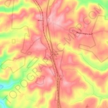
Nom : Carte topographique Flat Rock, altitude, relief.
Lieu : Flat Rock, McCreary County, Kentucky, 42653, United States (36.77675 -84.50466 36.81675 -84.46466)
Altitude moyenne : 374 m
Altitude minimum : 263 m
Altitude maximum : 424 m
Autres cartes topographiques
Cliquez sur une carte pour visualiser sa topographie, son altitude et son relief.
Stearns
United States > Kentucky > McCreary County
Stearns, McCreary County, Kentucky, United States
Altitude moyenne : 392 m
Yamacraw
United States > Kentucky > McCreary County
Yamacraw, McCreary County, Kentucky, 42647, United States
Altitude moyenne : 315 m
Bell Farm
United States > Kentucky > McCreary County
Bell Farm, McCreary County, Kentucky, United States
Altitude moyenne : 369 m
Strunk
United States > Kentucky > McCreary County > Strunk
Strunk, McCreary County, Kentucky, 42649, United States
Altitude moyenne : 410 m
Pine Knot
United States > Kentucky > McCreary County
Pine Knot, McCreary County, Kentucky, United States
Altitude moyenne : 399 m
Whitley City
United States > Kentucky > McCreary County
Whitley City, McCreary County, Kentucky, 42563, United States
Altitude moyenne : 390 m