
Carte topographique Dufftown
Carte interactive
Cliquez sur la carte pour afficher l’altitude.
À propos de cette carte
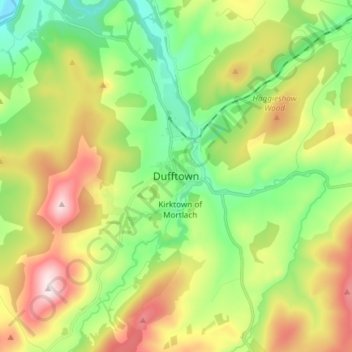
Nom : Carte topographique Dufftown, altitude, relief.
Lieu : Dufftown, Moray, Scotland, AB55 4AD, United Kingdom (57.40490 -3.16835 57.48490 -3.08835)
Altitude moyenne : 268 m
Altitude minimum : 79 m
Altitude maximum : 567 m
Autres cartes topographiques
Cliquez sur une carte pour visualiser sa topographie, son altitude et son relief.
Glenlivet
United Kingdom > Scotland > Moray
Glenlivet, Moray, Scotland, AB37 9BT, United Kingdom
Altitude moyenne : 280 m
Spey Bay
United Kingdom > Scotland > Moray
Spey Bay, Moray, Scotland, IV32 7RR, United Kingdom
Altitude moyenne : 5 m
Longmorn
United Kingdom > Scotland > Moray > Longmorn
Longmorn, Moray, Scotland, IV30 8SA, United Kingdom
Altitude moyenne : 67 m
Dallas
United Kingdom > Scotland > Moray
Dallas, Moray, Scotland, IV36 2SA, United Kingdom
Altitude moyenne : 205 m
Ballindalloch
United Kingdom > Scotland > Moray > Ballindalloch
Ballindalloch, Moray, Scotland, AB37 9YF, United Kingdom
Altitude moyenne : 233 m
Forres
United Kingdom > Scotland > Moray > Forres
Forres, Moray, Scotland, IV36 1NX, United Kingdom
Altitude moyenne : 31 m
Kinloss
United Kingdom > Scotland > Moray
Kinloss, Moray, Scotland, IV36 3UT, United Kingdom
Altitude moyenne : 10 m