
Carte topographique Ariel
Carte interactive
Cliquez sur la carte pour afficher l’altitude.
À propos de cette carte
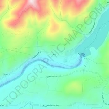
Nom : Carte topographique Ariel, altitude, relief.
Lieu : Ariel, Cowlitz County, Washington, United States (45.93678 -122.59093 45.97678 -122.55093)
Altitude moyenne : 206 m
Altitude minimum : 12 m
Altitude maximum : 662 m
Autres cartes topographiques
Cliquez sur une carte pour visualiser sa topographie, son altitude et son relief.
Longview
United States > Washington > Cowlitz County
Longview, Cowlitz County, Washington, United States
Altitude moyenne : 50 m
Kelso
United States > Washington > Cowlitz County
Kelso, Cowlitz County, Washington, 98626, United States
Altitude moyenne : 52 m
Silver Lake
United States > Washington > Cowlitz County
Silver Lake, Cowlitz County, Washington, 98645, United States
Altitude moyenne : 159 m
West Side Highway
United States > Washington > Cowlitz County
West Side Highway, Beacon Hill, Cowlitz County, Washington, United States
Altitude moyenne : 77 m
Pekin Ferry
United States > Washington > Cowlitz County
Pekin Ferry, Cowlitz County, Washington, United States
Altitude moyenne : 41 m
Yale
United States > Washington > Cowlitz County
Yale, Cowlitz County, Washington, 98603, United States
Altitude moyenne : 257 m
Eufaula
United States > Washington > Cowlitz County
Eufaula, Cowlitz County, Washington, United States
Altitude moyenne : 126 m
Ryderwood
United States > Washington > Cowlitz County
Ryderwood, Cowlitz County, Washington, 98581, United States
Altitude moyenne : 158 m
Toutle
United States > Washington > Cowlitz County
Toutle, Cowlitz County, Washington, 98645, United States
Altitude moyenne : 173 m
Kelso Doughnut Hole
United States > Washington > Cowlitz County
Kelso Doughnut Hole, Cowlitz County, Washington, United States
Altitude moyenne : 8 m
Kalama
United States > Washington > Cowlitz County
Kalama, Cowlitz County, Washington, 98625, United States
Altitude moyenne : 58 m
Woodland
United States > Washington > Cowlitz County
Woodland, Cowlitz County, Washington, 98674, United States
Altitude moyenne : 36 m
Coal Creek
United States > Washington > Cowlitz County
Coal Creek, Cowlitz County, Washington, United States
Altitude moyenne : 132 m
Castle Rock
United States > Washington > Cowlitz County
Castle Rock, Cowlitz County, Washington, 98611, United States
Altitude moyenne : 55 m
Rose Valley
United States > Washington > Cowlitz County
Rose Valley, Cowlitz County, Washington, 98609, United States
Altitude moyenne : 148 m
Woodland
United States > Washington > Cowlitz County > Woodland > Woodland
Woodland, Cowlitz County, Washington, 98674, United States
Altitude moyenne : 58 m
Kelso
United States > Washington > Cowlitz County > Kelso > Kelso
Kelso, Cowlitz County, Washington, 98626, United States
Altitude moyenne : 70 m
Cougar
United States > Washington > Cowlitz County
Cougar, Cowlitz County, Washington, 98616, United States
Altitude moyenne : 311 m
Longview
United States > Washington > Cowlitz County > Longview > Longview
Longview, Cowlitz County, Washington, 98626, United States
Altitude moyenne : 26 m
Stella
United States > Washington > Cowlitz County
Stella, Cowlitz County, Washington, United States
Altitude moyenne : 59 m