
Faire un don
Équipez-vous pour votre prochaine aventure :
En tant que Partenaire Amazon, ce site perçoit une commission sur les achats éligibles sans surcoût pour vous.
Carte topographique Summerhaven
Cliquez sur la carte pour afficher l’altitude.
Faire un don
Équipez-vous pour votre prochaine aventure :
En tant que Partenaire Amazon, ce site perçoit une commission sur les achats éligibles sans surcoût pour vous.
À propos de cette carte
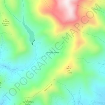
Nom : Carte topographique Summerhaven, altitude, relief.
Altitude moyenne : 955 m
Altitude minimum : 699 m
Altitude maximum : 1 445 m
Faire un don
Équipez-vous pour votre prochaine aventure :
En tant que Partenaire Amazon, ce site perçoit une commission sur les achats éligibles sans surcoût pour vous.
Autres cartes topographiques
Cliquez sur une carte pour visualiser sa topographie, son altitude et son relief.
Pisgah National Forest
United States > North Carolina > Buncombe County
The Pisgah National Forest covers 512,758 acres (801 sq mi; 2,075 km2) of mountainous terrain in the southern Appalachian Mountains, including parts of the Blue Ridge Mountains and Great Balsam Mountains. Elevations reach over 6,000 feet (1,800 m) and include some of the highest mountains in the eastern United…
Altitude moyenne : 752 m
Royal Pines
United States > North Carolina > Buncombe County > Royal Pines
Royal Pines is bordered to the west by U.S. Route 25A and the city limits of Asheville, and to the northeast by Mills Gap Road. Brown Mountain, with an elevation of 2,996 feet (913 m), occupies the center of the CDP.
Altitude moyenne : 714 m
Faire un don
Équipez-vous pour votre prochaine aventure :
En tant que Partenaire Amazon, ce site perçoit une commission sur les achats éligibles sans surcoût pour vous.
Beaver Lake
United States > North Carolina > Buncombe County > Asheville > Grace
Altitude moyenne : 672 m