
Carte topographique Oberhof
Carte interactive
Cliquez sur la carte pour afficher l’altitude.
À propos de cette carte
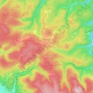
Nom : Carte topographique Oberhof, altitude, relief.
Altitude moyenne : 749 m
Altitude minimum : 488 m
Altitude maximum : 976 m
Autres cartes topographiques
Cliquez sur une carte pour visualiser sa topographie, son altitude et son relief.
Grabfeld
Duitsland > Thüringen > Landkreis Schmalkalden-Meiningen
Grabfeld, Landkreis Schmalkalden-Meiningen, Thüringen, 98631, Duitsland
Altitude moyenne : 384 m