
Carte topographique Forest of Arden
Carte interactive
Cliquez sur la carte pour afficher l’altitude.
À propos de cette carte
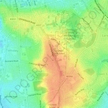
Nom : Carte topographique Forest of Arden, altitude, relief.
Lieu : Forest of Arden, Whitley, Reading, England, United Kingdom (51.43166 -0.95065 51.43912 -0.94546)
Altitude moyenne : 64 m
Altitude minimum : 42 m
Altitude maximum : 85 m
Autres cartes topographiques
Cliquez sur une carte pour visualiser sa topographie, son altitude et son relief.
Prospect Park
United Kingdom > England > Reading
Prospect Park, Southcote, Reading, England, RG30 2ND, United Kingdom
Altitude moyenne : 56 m
View Island
United Kingdom > England > Reading
View Island, Reading Hydro, Caversham, Reading, England, United Kingdom
Altitude moyenne : 45 m
Whiteknights Lake
United Kingdom > England > Reading
Whiteknights Lake, Whiteknights Road, Newtown, Reading, South East, England, RG6 7BY, United Kingdom
Altitude moyenne : 61 m