
Carte topographique Morrison
Carte interactive
Cliquez sur la carte pour afficher l’altitude.
À propos de cette carte
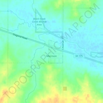
Nom : Carte topographique Morrison, altitude, relief.
Lieu : Morrison, Grundy County, Iowa, 50657, United States (42.34021 -92.67572 42.34631 -92.67074)
Altitude moyenne : 295 m
Altitude minimum : 284 m
Altitude maximum : 317 m
Autres cartes topographiques
Cliquez sur une carte pour visualiser sa topographie, son altitude et son relief.
Grundy Center
United States > Iowa > Grundy County
Grundy Center, Grundy County, Iowa, United States
Altitude moyenne : 306 m
Dike
United States > Iowa > Grundy County
Dike, Grundy County, Iowa, United States
Altitude moyenne : 291 m
Beaman
United States > Iowa > Grundy County
Beaman, Grundy County, Iowa, United States
Altitude moyenne : 309 m
Wellsburg
United States > Iowa > Grundy County
Wellsburg, Grundy County, Iowa, United States
Altitude moyenne : 327 m
Holland
United States > Iowa > Grundy County
Holland, Grundy County, Iowa, United States
Altitude moyenne : 310 m
Reinbeck
United States > Iowa > Grundy County
Reinbeck, Grundy County, Iowa, 50669, United States
Altitude moyenne : 290 m
Conrad
United States > Iowa > Grundy County
Conrad, Grundy County, Iowa, 50621, United States
Altitude moyenne : 313 m
Stout
United States > Iowa > Grundy County
Stout, Grundy County, Iowa, 50673, United States
Altitude moyenne : 309 m