
Faire un don
Équipez-vous pour votre prochaine aventure :
En tant que Partenaire Amazon, ce site perçoit une commission sur les achats éligibles sans surcoût pour vous.
Carte topographique Birgunj
Cliquez sur la carte pour afficher l’altitude.
Faire un don
Équipez-vous pour votre prochaine aventure :
En tant que Partenaire Amazon, ce site perçoit une commission sur les achats éligibles sans surcoût pour vous.
Birgunj
Birgunj is located in the Terai plain which is the northern part of the Indo-Gangetic plain. Birgunj metropolitan city has an elongated shape. The variation in altitude is in the range of 78 m to 95 m when moving from south to north of Birgunj. Although the range of altitude variation is small, but there is a high micro-topographical variation. The city lies about 90 m above sea level. Quaternary sediments are mainly found in the area. Soil is very fertile that consists the mixture of clay, silt and sand.
Faire un don
Équipez-vous pour votre prochaine aventure :
En tant que Partenaire Amazon, ce site perçoit une commission sur les achats éligibles sans surcoût pour vous.
À propos de cette carte
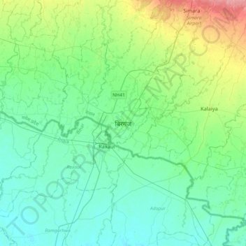
Nom : Carte topographique Birgunj, altitude, relief.
Altitude moyenne : 88 m
Altitude minimum : 69 m
Altitude maximum : 152 m
Faire un don
Équipez-vous pour votre prochaine aventure :
En tant que Partenaire Amazon, ce site perçoit une commission sur les achats éligibles sans surcoût pour vous.