
Faire un don
Équipez-vous pour votre prochaine aventure :
En tant que Partenaire Amazon, ce site perçoit une commission sur les achats éligibles sans surcoût pour vous.
Carte topographique Kandukur
Cliquez sur la carte pour afficher l’altitude.
Faire un don
Équipez-vous pour votre prochaine aventure :
En tant que Partenaire Amazon, ce site perçoit une commission sur les achats éligibles sans surcoût pour vous.
Kandukur
Kandukuru (earlier known as Skandapuri) is located at 15°12′59″N 79°54′15″E / 15.2165°N 79.9042°E / 15.2165; 79.9042. It has an average elevation of 13 metres (43 ft). Kandukur was a part of the erstwhile Nellore district and was then included in the newly carved out Prakasam District in 1970. Later as a part of the district's reorganization in 2022, it is now merged with the residual SPSR Nellore district. The total geographical area of Kandukur Municipality is 37.63 sq km.
Faire un don
Équipez-vous pour votre prochaine aventure :
En tant que Partenaire Amazon, ce site perçoit une commission sur les achats éligibles sans surcoût pour vous.
À propos de cette carte
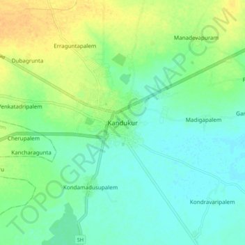
Nom : Carte topographique Kandukur, altitude, relief.
Altitude moyenne : 18 m
Altitude minimum : 7 m
Altitude maximum : 36 m
Faire un don
Équipez-vous pour votre prochaine aventure :
En tant que Partenaire Amazon, ce site perçoit une commission sur les achats éligibles sans surcoût pour vous.
Autres cartes topographiques
Cliquez sur une carte pour visualiser sa topographie, son altitude et son relief.