
Faire un don
Équipez-vous pour votre prochaine aventure :
En tant que Partenaire Amazon, ce site perçoit une commission sur les achats éligibles sans surcoût pour vous.
Carte topographique Daraban Tehsil
Cliquez sur la carte pour afficher l’altitude.
Faire un don
Équipez-vous pour votre prochaine aventure :
En tant que Partenaire Amazon, ce site perçoit une commission sur les achats éligibles sans surcoût pour vous.
Daraban Tehsil
Daraban is a tehsil located in Dera Ismail Khan District, Khyber Pakhtunkhwa, Pakistan. It is located at 31°44'3N 70°20'11E and has an altitude of 221 metres (725 ft). Daraban is a small town which lies 40 miles (64 km) west of Dera Ismail khan in the foothills of Sulaiman Mountains. Daraban region has a rich, fascinating history. Over the last two decades or so, Daraban has seen massive growth, becoming a vibrant hub of local trade and business.This has led to influx of economic migrants from neighboring villages, who have begin to settle in outskirts of Daraban, causing an increase in Town's population. Daraban enjoys excellent geographical condition, it lies on major national highway connecting Khyber Pakhtunkhuwa and Punjab with eastern parts of Balochistan.The town recent history includes events like high profile insurgent led attack on Draban's police station which led to deaths of 23 security personnels. This was only occasion when town gained media attention in Pakistan and abroad. December 12,2023 attack and more recent one in Chaudwan on February 5,2024 reflect heightened security threats in the region.
Faire un don
Équipez-vous pour votre prochaine aventure :
En tant que Partenaire Amazon, ce site perçoit une commission sur les achats éligibles sans surcoût pour vous.
À propos de cette carte
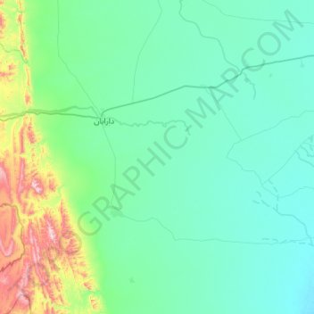
Nom : Carte topographique Daraban Tehsil, altitude, relief.
Altitude moyenne : 272 m
Altitude minimum : 163 m
Altitude maximum : 925 m
Faire un don
Équipez-vous pour votre prochaine aventure :
En tant que Partenaire Amazon, ce site perçoit une commission sur les achats éligibles sans surcoût pour vous.
Autres cartes topographiques
Cliquez sur une carte pour visualiser sa topographie, son altitude et son relief.
Dera Ismail Khan
Pakistan > Khyber Pakhtunkhwa > Dera Ismail Khan District
D. I Khan is situated at an altitude of 177 metres above sea level.
Altitude moyenne : 177 m