
Carte topographique Tokat
Carte interactive
Cliquez sur la carte pour afficher l’altitude.
À propos de cette carte
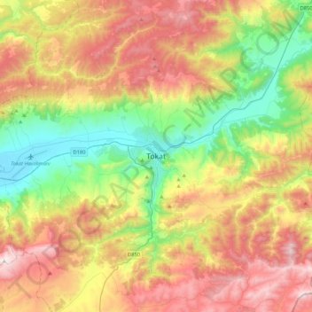
Nom : Carte topographique Tokat, altitude, relief.
Altitude moyenne : 1 137 m
Altitude minimum : 559 m
Altitude maximum : 1 908 m
Tokat has a hot-summer Mediterranean climate, or alternatively a continental climate (Köppen: Csa, Trewartha: Dc). Due to the relatively high altitude and inland location, winters are fairly cold with average lows below the freezing point and significant snowfall.