
Faire un don
Équipez-vous pour votre prochaine aventure :
En tant que Partenaire Amazon, ce site perçoit une commission sur les achats éligibles sans surcoût pour vous.
Carte topographique Vashon Island
Cliquez sur la carte pour afficher l’altitude.
Faire un don
Équipez-vous pour votre prochaine aventure :
En tant que Partenaire Amazon, ce site perçoit une commission sur les achats éligibles sans surcoût pour vous.
Vashon Island
Vashon Island features a diverse topography characterized by rolling hills, lush forests, and scenic waterfronts. The island rises gently from sea level to elevations reaching around 500 feet (approximately 150 meters) at its highest point, providing sweeping views of Puget Sound and the surrounding mountains. The terrain includes a mix of grassy meadows, dense woodlands, and rocky shorelines, creating a varied landscape that supports a rich array of flora and fauna. Additionally, the coastline is dotted with sandy beaches and tide pools, offering a dynamic interaction between land and sea. The combination of these natural features contributes to the island's serene beauty and ecological diversity.
Faire un don
Équipez-vous pour votre prochaine aventure :
En tant que Partenaire Amazon, ce site perçoit une commission sur les achats éligibles sans surcoût pour vous.
À propos de cette carte
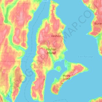
Nom : Carte topographique Vashon Island, altitude, relief.
Altitude moyenne : 46 m
Altitude minimum : -4 m
Altitude maximum : 154 m
Faire un don
Équipez-vous pour votre prochaine aventure :
En tant que Partenaire Amazon, ce site perçoit une commission sur les achats éligibles sans surcoût pour vous.