
Faire un don
Équipez-vous pour votre prochaine aventure :
En tant que Partenaire Amazon, ce site perçoit une commission sur les achats éligibles sans surcoût pour vous.
Carte topographique Amarillo
Cliquez sur la carte pour afficher l’altitude.
Faire un don
Équipez-vous pour votre prochaine aventure :
En tant que Partenaire Amazon, ce site perçoit une commission sur les achats éligibles sans surcoût pour vous.
Amarillo
Extreme temperatures range from −16 °F (−26.7 °C) on February 12, 1899 to 111 °F (43.9 °C) on June 26, 2011, but lows do not typically dip to 0 °F or −17.8 °C in most years, while highs above 100 °F or 37.8 °C are seen on 4.7 days on average. On average, there are 5.9 days of lows at or below 10 °F or −12.2 °C, 8.8 days where the temperature fails to rise above freezing, and 61 days of 90 °F (32.2 °C)+ highs. Unlike in the Rio Grande Valley or eastern portions of Texas, days where the low does not fall below 70 °F or 21.1 °C are relatively rare, due to the aridity and elevation. Blizzards occur occasionally, but snowfall is typically light, averaging nearly 18 inches or 46 centimetres seasonally and the median figure is near 10 inches or 25 centimetres. Amarillo is also recorded as the windiest city in the U.S. by the Weather Channel.
Faire un don
Équipez-vous pour votre prochaine aventure :
En tant que Partenaire Amazon, ce site perçoit une commission sur les achats éligibles sans surcoût pour vous.
À propos de cette carte
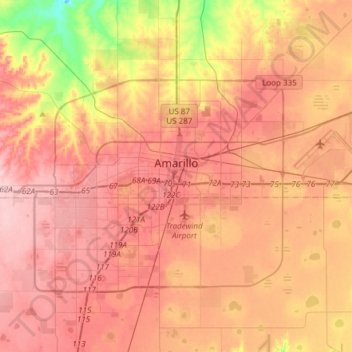
Nom : Carte topographique Amarillo, altitude, relief.
Lieu : Amarillo, Potter County, Texas, United States (35.10200 -101.95624 35.29448 -101.65378)
Altitude moyenne : 1 097 m
Altitude minimum : 999 m
Altitude maximum : 1 154 m
Faire un don
Équipez-vous pour votre prochaine aventure :
En tant que Partenaire Amazon, ce site perçoit une commission sur les achats éligibles sans surcoût pour vous.
Autres cartes topographiques
Cliquez sur une carte pour visualiser sa topographie, son altitude et son relief.
Amarillo
United States > Texas > Potter County
Amarillo features a unique topography characterized by its high elevation and flat plains. The city averages around 3,600 feet (1,097 meters) above sea level, making it one of the highest major cities in Texas. The surrounding landscape consists of the Llano Estacado, a vast tabletop plateau that slopes…
Altitude moyenne : 1 098 m
Bushland
United States > Texas > Potter County
Bushland is located at 35°11′31″N 102°03′53″W / 35.19194°N 102.06472°W / 35.19194; -102.06472 (35.1919978, -102.0646392), at an elevation of 3,825 feet. The community is situated along Interstate 40, approximately 14 miles west of Amarillo in southwestern Potter County.
Altitude moyenne : 1 167 m
Amarillo
United States > Texas > Potter County
Extreme temperatures range from −16 °F (−26.7 °C) on February 12, 1899 to 111 °F (43.9 °C) on June 26, 2011, but lows do not typically dip to 0 °F or −17.8 °C in most years, while highs above 100 °F or 37.8 °C are seen on 4.7 days on average. On average, there are 5.9 days of lows at or below 10…
Altitude moyenne : 1 098 m
Faire un don
Équipez-vous pour votre prochaine aventure :
En tant que Partenaire Amazon, ce site perçoit une commission sur les achats éligibles sans surcoût pour vous.
Amarillo
United States > Texas > Potter County
Extreme temperatures range from −16 °F (−26.7 °C) on February 12, 1899 to 111 °F (43.9 °C) on June 26, 2011, but lows do not typically dip to 0 °F or −17.8 °C in most years, while highs above 100 °F or 37.8 °C are seen on 4.7 days on average. On average, there are 5.9 days of lows at or below 10…
Altitude moyenne : 1 098 m