
Faire un don
Équipez-vous pour votre prochaine aventure :
En tant que Partenaire Amazon, ce site perçoit une commission sur les achats éligibles sans surcoût pour vous.
Carte topographique Sulur
Cliquez sur la carte pour afficher l’altitude.
Faire un don
Équipez-vous pour votre prochaine aventure :
En tant que Partenaire Amazon, ce site perçoit une commission sur les achats éligibles sans surcoût pour vous.
Sulur
Sulur is located at 11°01′31″N 77°07′29″E / 11.0254°N 77.1246°E / 11.0254; 77.1246. It has an average elevation of 340 metres (1115 feet). Sulur is regarded as a pleasant town situated very close to the cities of Coimbatore "Manchester of South India" (19 km) and Tirupur (35 km). Thus it is a popular location for various textile mills and weaving slots. Near to Sulur there is a railway station and an Air Force base. The twin lakes to the north of the town, bounding the Coimbatore-Nagapattinam highway adds a scenic view to the town. The town is divided into two parts by the holy Noyyal River. Sulur is the East-end of the new Coimbatore district.
Faire un don
Équipez-vous pour votre prochaine aventure :
En tant que Partenaire Amazon, ce site perçoit une commission sur les achats éligibles sans surcoût pour vous.
À propos de cette carte
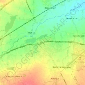
Nom : Carte topographique Sulur, altitude, relief.
Lieu : Sulur, Coimbatore, Tamil Nadu, 641402, India (10.98689 77.08586 11.06689 77.16586)
Altitude moyenne : 371 m
Altitude minimum : 343 m
Altitude maximum : 405 m
Faire un don
Équipez-vous pour votre prochaine aventure :
En tant que Partenaire Amazon, ce site perçoit une commission sur les achats éligibles sans surcoût pour vous.
Autres cartes topographiques
Cliquez sur une carte pour visualiser sa topographie, son altitude et son relief.
Pallapalayam - Kannampalayam Canal
India > Tamil Nadu > Sulur > Kannampalayam
Altitude moyenne : 381 m