
Carte topographique Big Rock
Carte interactive
Cliquez sur la carte pour afficher l’altitude.
À propos de cette carte
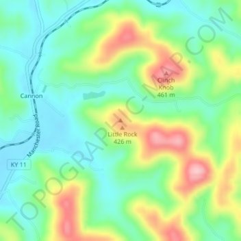
Nom : Carte topographique Big Rock, altitude, relief.
Lieu : Big Rock, Knox County, Kentucky, 40923, United States (36.91170 -83.84581 36.91180 -83.84571)
Altitude moyenne : 355 m
Altitude minimum : 296 m
Altitude maximum : 465 m
Autres cartes topographiques
Cliquez sur une carte pour visualiser sa topographie, son altitude et son relief.
Walker
United States > Kentucky > Knox County
Walker, Knox County, Kentucky, 40997, United States
Altitude moyenne : 403 m
Hinkle
United States > Kentucky > Knox County
Hinkle, Knox County, Kentucky, 40915, United States
Altitude moyenne : 368 m
Flat Lick
United States > Kentucky > Knox County
Flat Lick, Knox County, Kentucky, 40935, United States
Altitude moyenne : 349 m
Barbourville
United States > Kentucky > Knox County
Barbourville, Knox County, Kentucky, 40906, United States
Altitude moyenne : 323 m
Baughman
United States > Kentucky > Knox County > Baughman
Baughman, Knox County, Kentucky, 40915, United States
Altitude moyenne : 360 m