
Carte topographique Taylor Mill
Carte interactive
Cliquez sur la carte pour afficher l’altitude.
À propos de cette carte
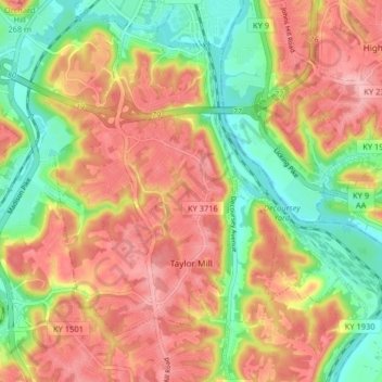
Nom : Carte topographique Taylor Mill, altitude, relief.
Lieu : Taylor Mill, Kenton County, Kentucky, 41015, United States (38.97794 -84.52537 39.04084 -84.45057)
Altitude moyenne : 211 m
Altitude minimum : 138 m
Altitude maximum : 277 m
Autres cartes topographiques
Cliquez sur une carte pour visualiser sa topographie, son altitude et son relief.
Fort Wright
United States > Kentucky > Kenton County
Fort Wright, Kenton County, Kentucky, United States
Altitude moyenne : 219 m
Pride Park
United States > Kentucky > Kenton County > Taylor Mill
Pride Park, Taylor Mill, Kenton County, Kentucky, United States
Altitude moyenne : 237 m
Piner
United States > Kentucky > Kenton County
Piner, Kenton County, Kentucky, 41163, United States
Altitude moyenne : 251 m
Covington
United States > Kentucky > Kenton County
Covington, Kenton County, Kentucky, United States
Altitude moyenne : 215 m
Independence
United States > Kentucky > Kenton County
Independence, Kenton County, Kentucky, 41051, United States
Altitude moyenne : 254 m
Erlanger
United States > Kentucky > Kenton County
Erlanger, Kenton County, Kentucky, 41018, United States
Altitude moyenne : 258 m
Daniel Carter Beard Boyhood Home
United States > Kentucky > Kenton County > Covington
Daniel Carter Beard Boyhood Home, Licking Riverside Historic District, Covington, Kenton County, Kentucky, United States
Altitude moyenne : 157 m
Edgewood
United States > Kentucky > Kenton County
Edgewood, Kenton County, Kentucky, United States
Altitude moyenne : 258 m
Austinburg
United States > Kentucky > Kenton County > Covington > Austinburg
Austinburg, Covington, Kenton County, Kentucky, 41014, United States
Altitude moyenne : 178 m
Fort Mitchell
United States > Kentucky > Kenton County
Fort Mitchell, Kenton County, Kentucky, United States
Altitude moyenne : 235 m
Crestview Hills
United States > Kentucky > Kenton County
Crestview Hills, Kenton County, Kentucky, United States
Altitude moyenne : 259 m