
Carte topographique Balut Island
Carte interactive
Cliquez sur la carte pour afficher l’altitude.
Balut Island
Balut Island, the westernmost of the Sarangani Islands, is the larger, higher, and better cultivated than Sarangani Island. In the center of the island is Balut Volcano, which is fumarolic on occasion. Balut Island rises to about 1,800 metres (5,900 ft) from the seabed with the highest elevation at 862 metres (2,828 ft) above mean sea level. Base diameter of the island is 8 kilometres (5.0 mi).
À propos de cette carte
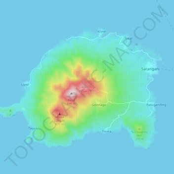
Nom : Carte topographique Balut Island, altitude, relief.
Altitude moyenne : 87 m
Altitude minimum : 0 m
Altitude maximum : 827 m
Autres cartes topographiques
Cliquez sur une carte pour visualiser sa topographie, son altitude et son relief.