
Carte topographique Ganderbal
Carte interactive
Cliquez sur la carte pour afficher l’altitude.
À propos de cette carte
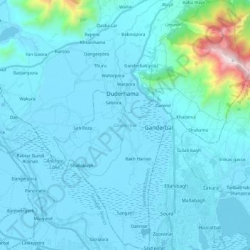
Nom : Carte topographique Ganderbal, altitude, relief.
Lieu : Ganderbal, Ganderbal district, Jammu and Kashmir, India (34.11255 74.71491 34.27296 74.93139)
Altitude moyenne : 1 885 m
Altitude minimum : 1 580 m
Altitude maximum : 3 443 m
Autres cartes topographiques
Cliquez sur une carte pour visualiser sa topographie, son altitude et son relief.
Darend
India > Jammu and Kashmir > Ganderbal
Darend, Ganderbal, Ganderbal District, Jammu and Kashmir, 191201, India
Altitude moyenne : 1 666 m