
Carte topographique Wix
Cliquez sur la carte pour afficher l’altitude.
À propos de cette carte
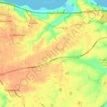
Nom : Carte topographique Wix, altitude, relief.
Lieu : Wix, Tendring, Essex, England, United Kingdom (51.89722 1.08625 51.93441 1.18230)
Altitude moyenne : 25 m
Altitude minimum : -1 m
Altitude maximum : 38 m
Autres cartes topographiques
Cliquez sur une carte pour visualiser sa topographie, son altitude et son relief.
Hedingham Castle
United Kingdom > England > Essex > Braintree > Castle Hedingham
Altitude moyenne : 67 m
Coles Green
United Kingdom > England > Essex > Uttlesford > Berden > Little London
Altitude moyenne : 100 m
Nazeing Gate
United Kingdom > England > Essex > Epping Forest > Bumble's Green > Nazeing
Altitude moyenne : 70 m
Roughtalley's Wood (South) & Epping Forest Woodland Burial Ground
United Kingdom > England > Essex > Epping Forest > Coopersale
Altitude moyenne : 96 m
Watch House Green
United Kingdom > England > Essex > Uttlesford > Felsted > Watch House Green
Altitude moyenne : 69 m
Wivenhoe Woods
United Kingdom > England > Essex > Colchester > Wivenhoe > Rowhedge
Altitude moyenne : 18 m
M25 Pollution Control Device
United Kingdom > England > Essex > South Ockendon
Altitude moyenne : 19 m