Géolocaliser

Carte topographique Limpsfield Chart

Cliquez sur la carte pour afficher l’altitude.

À propos de cette carte

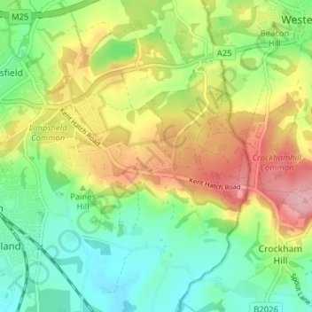
Nom : Carte topographique Limpsfield Chart, altitude, relief.

Lieu : Limpsfield Chart, Limpsfield, Tandridge, Surrey, England, RH8 0TR, United Kingdom (51.22956 0.01891 51.26956 0.05891)

Altitude moyenne : 126 m

Altitude minimum : 66 m

Altitude maximum : 214 m

Autres cartes topographiques

Cliquez sur une carte pour visualiser sa topographie, son altitude et son relief.

Warlingham

United Kingdom > England > Surrey > Tandridge

Elevations vary from 110m AOD at Woldingham Road, at the southernmost point of the parish, with a gentle increase in height through the village along the main road heading to the southeast, to the highest elevation (199.6m) at Limpsfield Road.

Altitude moyenne : 163 m

Caterham-on-the-Hill

United Kingdom > England > Surrey > Tandridge

Altitude moyenne : 168 m

Godstone

United Kingdom > England > Surrey > Tandridge

Altitude moyenne : 91 m

Burstow

United Kingdom > England > Surrey > Tandridge

Altitude moyenne : 67 m

Warlingham

United Kingdom > England > Surrey > Tandridge

Elevations vary from 110m AOD at Woldingham Road, at the southernmost point of the parish, with a gentle increase in height through the village along the main road heading to the southeast, to the highest elevation (199.6m) at Limpsfield Road.

Altitude moyenne : 163 m

Tatsfield

United Kingdom > England > Surrey > Tandridge

Altitude moyenne : 176 m

Titsey

United Kingdom > England > Surrey > Tandridge

Altitude moyenne : 185 m

Crowhurst

United Kingdom > England > Surrey > Tandridge

Altitude moyenne : 62 m

Oxted

United Kingdom > England > Surrey > Tandridge

Altitude moyenne : 128 m

Woldingham

United Kingdom > England > Surrey > Tandridge

Altitude moyenne : 183 m

Chaldon

United Kingdom > England > Surrey > Tandridge

Altitude moyenne : 181 m

Horne

United Kingdom > England > Surrey > Tandridge

Altitude moyenne : 68 m

Équipez-vous pour votre prochaine aventure :

🗺️Carte à Gratter - Marquez les pays et régions que vous avez explorés.
👖Pantalon de Marche - Pantalon transformable en short pour s'adapter au climat.
🧭Altimètres et baromètres - Mesure altitude et pression atmosphérique
🎒Sacs à dos de randonnée - Sacs ergonomiques pour randonnées à la journée ou treks longue durée
🔥Réchaud de Camping - Matériel de cuisson compact et rapide pour vos repas en bivouac.

En tant que Partenaire Amazon, ce site perçoit une commission sur les achats éligibles sans surcoût pour vous.