
Carte topographique Pioneer Weapons Wildlife Management Area
Carte interactive
Cliquez sur la carte pour afficher l’altitude.
À propos de cette carte
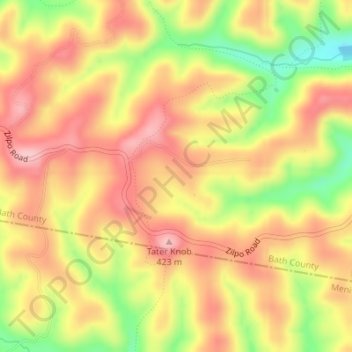
Nom : Carte topographique Pioneer Weapons Wildlife Management Area, altitude, relief.
Altitude moyenne : 323 m
Altitude minimum : 223 m
Altitude maximum : 390 m
Autres cartes topographiques
Cliquez sur une carte pour visualiser sa topographie, son altitude et son relief.
Sharpsburg
United States > Kentucky > Bath County
Sharpsburg, Bath County, Kentucky, United States
Altitude moyenne : 297 m
Olympia
United States > Kentucky > Bath County
Olympia, Bath County, Kentucky, 40358, United States
Altitude moyenne : 248 m
Owingsville
United States > Kentucky > Bath County
Owingsville, Bath County, Kentucky, 40360, United States
Altitude moyenne : 262 m
Salt Lick
United States > Kentucky > Bath County
Salt Lick, Bath County, Kentucky, United States
Altitude moyenne : 217 m