
Carte topographique Bucharest
Carte interactive
Cliquez sur la carte pour afficher l’altitude.
À propos de cette carte
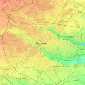
Nom : Carte topographique Bucharest, altitude, relief.
Lieu : Bucharest, Romania (44.33425 25.96667 44.54140 26.22558)
Altitude moyenne : 82 m
Altitude minimum : 49 m
Altitude maximum : 117 m
The city has an area of 226 km2 (87 sq mi). The altitude varies from 55.8 m (183.1 ft) at the Dâmbovița bridge in Cățelu, southeastern Bucharest and 91.5 m (300.2 ft) at the Militari church. The city has a roughly round shape, with the centre situated in the cross-way of the main north–south/east-west axes at University Square. The milestone for Romania's Kilometre Zero is placed just south of University Square in front of the New St. George Church (Sfântul Gheorghe Nou) at St. George Square (Piața Sfântul Gheorghe). Bucharest's radius, from University Square to the city limits in all directions, varies from 10 to 12 km (6 to 7 mi).
Autres cartes topographiques
Cliquez sur une carte pour visualiser sa topographie, son altitude et son relief.
Dorolea
Dorolea, Livezile, Bistrița-Năsăud, 427122, Romania
Altitude moyenne : 488 m
Dealul cu Drum
Dealul cu Drum, Greci, Tulcea, 827080, Romania
Altitude moyenne : 168 m
Carpathian Mountains
Carpathian Mountains, Toplița, Harghita, 535705, Romania
Altitude moyenne : 980 m