
Faire un don
Équipez-vous pour votre prochaine aventure :
En tant que Partenaire Amazon, ce site perçoit une commission sur les achats éligibles sans surcoût pour vous.
Carte topographique Wallberg
Cliquez sur la carte pour afficher l’altitude.
Faire un don
Équipez-vous pour votre prochaine aventure :
En tant que Partenaire Amazon, ce site perçoit une commission sur les achats éligibles sans surcoût pour vous.
Wallberg
Der Anstieg von der Wallbergbahn-Talstation bei Rottach-Egern führt über einen Sattel links vorbei am Setzberg (1706 m) zur Bergstation der Wallbergbahn. Das dortige Panoramarestaurant Wallberg liegt in 1623 m Höhe. Nach weiteren 100 Höhenmetern erreicht man über einen Geröll- und Felspfad in etwa 20–30 Minuten den Gipfel mit dem Gipfelkreuz in 1722 m Höhe.
Faire un don
Équipez-vous pour votre prochaine aventure :
En tant que Partenaire Amazon, ce site perçoit une commission sur les achats éligibles sans surcoût pour vous.
À propos de cette carte
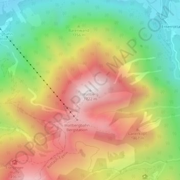
Nom : Carte topographique Wallberg, altitude, relief.
Altitude moyenne : 1 215 m
Altitude minimum : 747 m
Altitude maximum : 1 697 m
Faire un don
Équipez-vous pour votre prochaine aventure :
En tant que Partenaire Amazon, ce site perçoit une commission sur les achats éligibles sans surcoût pour vous.