
Carte topographique Mitterfels
Cliquez sur la carte pour afficher l’altitude.
À propos de cette carte
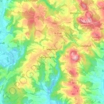
Nom : Carte topographique Mitterfels, altitude, relief.
Altitude moyenne : 398 m
Altitude minimum : 325 m
Altitude maximum : 489 m
Autres cartes topographiques
Cliquez sur une carte pour visualiser sa topographie, son altitude et son relief.
Untermühlbach
Deutschland > Bayern > Landkreis Straubing-Bogen > Obermühlbach
Altitude moyenne : 477 m
Niederlindhart
Deutschland > Bayern > Landkreis Straubing-Bogen > Mallersdorf-Pfaffenberg > Westen
Altitude moyenne : 407 m
Bogenberg
Deutschland > Bayern > Landkreis Straubing-Bogen > Bogen > Bogenberg
Altitude moyenne : 326 m
Irlbach an der Donau
Deutschland > Bayern > Landkreis Straubing-Bogen > Irlbach
Altitude moyenne : 321 m
St. Leonhardsquelle
Deutschland > Bayern > Landkreis Straubing-Bogen > Mitterberg
Altitude moyenne : 808 m
Hinterdegenberg
Deutschland > Bayern > Landkreis Straubing-Bogen > Allersdorf
Altitude moyenne : 578 m
Westen
Deutschland > Bayern > Landkreis Straubing-Bogen > Mallersdorf-Pfaffenberg
Altitude moyenne : 410 m
Grafentraubach
Deutschland > Bayern > Landkreis Straubing-Bogen
Das Pfarrdorf Grafentraubach liegt im Donau-Isar-Hügelland auf Höhen um 372 m ü. NHN am linken Rand des Tals der Kleinen Laber. Durch den Ort mündet der Grafentraubach in den Mittellauf des Flusses. Etwas über zwei Kilometer östlich liegt am anderen Rand der Flusstalaue der Gemeindesitz Laberweinting,…
Altitude moyenne : 390 m
Sallach
Deutschland > Bayern > Landkreis Straubing-Bogen > Geiselhöring > Sallach
Altitude moyenne : 372 m
Talmühle
Deutschland > Bayern > Landkreis Straubing-Bogen > Scheibelsgrub > Talmühle
Altitude moyenne : 408 m