
Carte topographique Wraysbury
Cliquez sur la carte pour afficher l’altitude.
Wraysbury
The new chapel, with its elegant slender tower, was opened on 16 October 1862; the building works had cost around £800. The striking terracotta relief panel, The City of Refuge, on the front elevation of the chapel, was created by the renowned Doulton & Co artist George Tinworth and is signed with his monogram. After Buckland's death, James Doulton, his son-in-law and a cousin of Sir Henry Doulton, took over the preaching duties. Later James' son-in-law the Reverend Arthur Gostick Shorrock took over the duties. Arthur had been a student preacher in Wraysbury in the 1880s, after which he spent 35 years as a missionary in Shaanxi, China.
À propos de cette carte
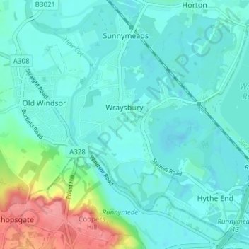
Nom : Carte topographique Wraysbury, altitude, relief.
Altitude moyenne : 25 m
Altitude minimum : 10 m
Altitude maximum : 90 m
Autres cartes topographiques
Cliquez sur une carte pour visualiser sa topographie, son altitude et son relief.
Windsor Marina
United Kingdom > England > Royal Borough of Windsor and Maidenhead > Oakley Green
Altitude moyenne : 26 m
Silwood Park
United Kingdom > England > Royal Borough of Windsor and Maidenhead > Beggar's Bush
Altitude moyenne : 61 m
Braywoodside
United Kingdom > England > Royal Borough of Windsor and Maidenhead
Altitude moyenne : 43 m
Sunninghill
United Kingdom > England > Royal Borough of Windsor and Maidenhead
Altitude moyenne : 67 m
Cookham Rise
United Kingdom > England > Royal Borough of Windsor and Maidenhead
Altitude moyenne : 44 m
Magna Carta Island
United Kingdom > England > Royal Borough of Windsor and Maidenhead > Wraysbury
Altitude moyenne : 32 m
Cookham Dean
United Kingdom > England > Royal Borough of Windsor and Maidenhead
Altitude moyenne : 50 m
Bridge Gardens
United Kingdom > England > Royal Borough of Windsor and Maidenhead > Maidenhead
Altitude moyenne : 30 m
Upton Court Park
United Kingdom > England > Royal Borough of Windsor and Maidenhead > Slough
Altitude moyenne : 23 m
Formosa Island
United Kingdom > England > Royal Borough of Windsor and Maidenhead > Cookham
Altitude moyenne : 48 m
Burchett's Green
United Kingdom > England > Royal Borough of Windsor and Maidenhead > Hurley
Altitude moyenne : 68 m
Windsor Castle
United Kingdom > England > Royal Borough of Windsor and Maidenhead > Windsor > Clewer Village
Altitude moyenne : 23 m
Oakley Green
United Kingdom > England > Royal Borough of Windsor and Maidenhead
Altitude moyenne : 37 m
Windsor Castle
United Kingdom > England > Royal Borough of Windsor and Maidenhead > Windsor > Clewer Village
Altitude moyenne : 23 m
Windsor Castle
United Kingdom > England > Royal Borough of Windsor and Maidenhead > Windsor > Clewer Village
Altitude moyenne : 23 m
Sunninghill
United Kingdom > England > Royal Borough of Windsor and Maidenhead
Altitude moyenne : 67 m
Cookham Rise
United Kingdom > England > Royal Borough of Windsor and Maidenhead
Altitude moyenne : 44 m
Cookham Dean
United Kingdom > England > Royal Borough of Windsor and Maidenhead
Altitude moyenne : 50 m
Windsor Castle
United Kingdom > England > Royal Borough of Windsor and Maidenhead > Windsor > Clewer Village
Altitude moyenne : 23 m