
Faire un don
Équipez-vous pour votre prochaine aventure :
En tant que Partenaire Amazon, ce site perçoit une commission sur les achats éligibles sans surcoût pour vous.
Carte topographique Jim Thorpe
Cliquez sur la carte pour afficher l’altitude.
Faire un don
Équipez-vous pour votre prochaine aventure :
En tant que Partenaire Amazon, ce site perçoit une commission sur les achats éligibles sans surcoût pour vous.
Jim Thorpe
In the deeps of the geologic timescale the two shorelines of the Lehigh River occupied by the 19th-century towns of Mauch Chunk and East Mauch Chunk were situated on the bottom of an ancient river-fed tarn, a mountain lake which filled the valley on the west bank and covered the relative flatlands on the east bank. The muddy bottom of that high tarn (the range then rivaling the Himalayas in size), where the waters pooled at a lower elevation amongst the twisted folds of four near-parallel ridgelines, created a level region whose settlements became the relatively flat lands on either bank of the Lehigh. The ridgelines, which run east-northeast to west-southwest, are (from north to south) Broad, Nesquehoning, Pisgah, and Mauch Chunk ridges (or Mountains)—each of which runs over 15 miles (24.1 km) west to the gaps cut by the Schuylkill River.
Faire un don
Équipez-vous pour votre prochaine aventure :
En tant que Partenaire Amazon, ce site perçoit une commission sur les achats éligibles sans surcoût pour vous.
À propos de cette carte
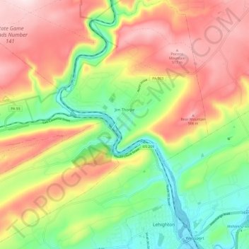
Nom : Carte topographique Jim Thorpe, altitude, relief.
Altitude moyenne : 327 m
Altitude minimum : 135 m
Altitude maximum : 541 m
Faire un don
Équipez-vous pour votre prochaine aventure :
En tant que Partenaire Amazon, ce site perçoit une commission sur les achats éligibles sans surcoût pour vous.
Autres cartes topographiques
Cliquez sur une carte pour visualiser sa topographie, son altitude et son relief.
Albrightsville
United States > Pennsylvania > Carbon County > Kidder Township
Altitude moyenne : 498 m
Holiday Poconos
United States > Pennsylvania > Carbon County > Kidder Township
Altitude moyenne : 519 m
Faire un don
Équipez-vous pour votre prochaine aventure :
En tant que Partenaire Amazon, ce site perçoit une commission sur les achats éligibles sans surcoût pour vous.
Hickory Run State Park
United States > Pennsylvania > Carbon County > Kidder Township
Altitude moyenne : 471 m
Lake Harmony
United States > Pennsylvania > Carbon County > Kidder Township > Lake Harmony
Altitude moyenne : 568 m
Beltzville State Park - Parking Lot B
United States > Pennsylvania > Carbon County > Lehighton
Altitude moyenne : 222 m
Faire un don
Équipez-vous pour votre prochaine aventure :
En tant que Partenaire Amazon, ce site perçoit une commission sur les achats éligibles sans surcoût pour vous.
Lake Harmony
United States > Pennsylvania > Carbon County > Kidder Township > Lake Harmony
Altitude moyenne : 551 m
Holiday Poconos
United States > Pennsylvania > Carbon County > Kidder Township
Altitude moyenne : 519 m
Albrightsville
United States > Pennsylvania > Carbon County > Kidder Township
Altitude moyenne : 498 m
Faire un don
Équipez-vous pour votre prochaine aventure :
En tant que Partenaire Amazon, ce site perçoit une commission sur les achats éligibles sans surcoût pour vous.
Germans
United States > Pennsylvania > Carbon County > East Penn Township > Germans
Altitude moyenne : 238 m
Holiday Poconos
United States > Pennsylvania > Carbon County > Kidder Township
Altitude moyenne : 519 m