
Faire un don
Équipez-vous pour votre prochaine aventure :
En tant que Partenaire Amazon, ce site perçoit une commission sur les achats éligibles sans surcoût pour vous.
Carte topographique Observatory Hill
Cliquez sur la carte pour afficher l’altitude.
Faire un don
Équipez-vous pour votre prochaine aventure :
En tant que Partenaire Amazon, ce site perçoit une commission sur les achats éligibles sans surcoût pour vous.
À propos de cette carte
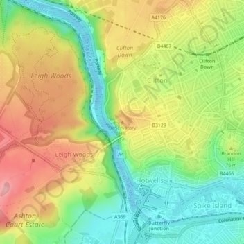
Nom : Carte topographique Observatory Hill, altitude, relief.
Altitude moyenne : 64 m
Altitude minimum : -14 m
Altitude maximum : 136 m
Faire un don
Équipez-vous pour votre prochaine aventure :
En tant que Partenaire Amazon, ce site perçoit une commission sur les achats éligibles sans surcoût pour vous.
Autres cartes topographiques
Cliquez sur une carte pour visualiser sa topographie, son altitude et son relief.
Castle Park
United Kingdom > England > City of Bristol > Bristol
The main objection to this plan came from the independent traders who did not wish to relocate because they felt that the proposed new shopping area was 'off the beaten track'. This objection was not unreasonable, as in its pre-war topography Bristol had a long shopping axis that started at Stapleton Road to…
Altitude moyenne : 26 m
Faire un don
Équipez-vous pour votre prochaine aventure :
En tant que Partenaire Amazon, ce site perçoit une commission sur les achats éligibles sans surcoût pour vous.
Faire un don
Équipez-vous pour votre prochaine aventure :
En tant que Partenaire Amazon, ce site perçoit une commission sur les achats éligibles sans surcoût pour vous.
Oldbury Court Estate/Vassals Park
United Kingdom > England > City of Bristol > Bristol
Altitude moyenne : 56 m
Brandon Hill Bowling Green
United Kingdom > England > City of Bristol > Bristol
Altitude moyenne : 38 m
Faire un don
Équipez-vous pour votre prochaine aventure :
En tant que Partenaire Amazon, ce site perçoit une commission sur les achats éligibles sans surcoût pour vous.
Moorgrove Wood
United Kingdom > England > City of Bristol > Bristol > Blaise Hamlet
Altitude moyenne : 40 m