
Faire un don
Équipez-vous pour votre prochaine aventure :
En tant que Partenaire Amazon, ce site perçoit une commission sur les achats éligibles sans surcoût pour vous.
Carte topographique Boyd Hill
Cliquez sur la carte pour afficher l’altitude.
Faire un don
Équipez-vous pour votre prochaine aventure :
En tant que Partenaire Amazon, ce site perçoit une commission sur les achats éligibles sans surcoût pour vous.
À propos de cette carte
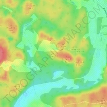
Nom : Carte topographique Boyd Hill, altitude, relief.
Lieu : Boyd Hill, Pierce County, Washington, 98433, United States (47.06050 -122.60571 47.06060 -122.60561)
Altitude moyenne : 107 m
Altitude minimum : 75 m
Altitude maximum : 145 m
Faire un don
Équipez-vous pour votre prochaine aventure :
En tant que Partenaire Amazon, ce site perçoit une commission sur les achats éligibles sans surcoût pour vous.
Autres cartes topographiques
Cliquez sur une carte pour visualiser sa topographie, son altitude et son relief.
Tacoma
United States > Washington > Pierce County
Tacoma is at 47°14′29″N 122°27′34″W / 47.24139°N 122.45944°W / 47.24139; -122.45944 (47.241371, −122.459389). Its official elevation is 381 feet (116 m), varying between sea level and about 500 feet (150 m).
Altitude moyenne : 67 m
Mount Rainier National Park
United States > Washington > Pierce County
Mount Rainier National Park is an American national park located in southeast Pierce County and northeast Lewis County in Washington state. The park was established on March 2, 1899 as the fifth national park in the United States, preserving 236,381 acres (369.3 sq mi; 956.6 km2) including all of Mount…
Altitude moyenne : 1 412 m
Winthrop Glacier
United States > Washington > Pierce County
The Winthrop Glacier is a large glacier on the northeastern side of Mount Rainier in Washington. Named after Theodore Winthrop, the body of ice covers 3.5 mile2 (9.1 km2) and has a volume of 18.5 billion feet3 (523 million m3). Starting at over 14,300 feet (4,400 m) at the Columbia Crest, the glacier heads…
Altitude moyenne : 2 404 m
Faire un don
Équipez-vous pour votre prochaine aventure :
En tant que Partenaire Amazon, ce site perçoit une commission sur les achats éligibles sans surcoût pour vous.
Greenwater
United States > Washington > Pierce County
Greenwater is located at the confluence of the Greenwater and White Rivers, at an approximate elevation of 1,700 feet (520 m) above sea level.
Altitude moyenne : 655 m
Tacoma
United States > Washington > Pierce County
Tacoma is at 47°14′29″N 122°27′34″W / 47.24139°N 122.45944°W / 47.24139; -122.45944 (47.241371, −122.459389). Its official elevation is 381 feet (116 m), varying between sea level and about 500 feet (150 m).
Altitude moyenne : 67 m
Faire un don
Équipez-vous pour votre prochaine aventure :
En tant que Partenaire Amazon, ce site perçoit une commission sur les achats éligibles sans surcoût pour vous.
Faire un don
Équipez-vous pour votre prochaine aventure :
En tant que Partenaire Amazon, ce site perçoit une commission sur les achats éligibles sans surcoût pour vous.
Puyallup
United States > Washington > Pierce County
Downtown Puyallup and nearby neighborhoods lie within the hazard zone for lahars that could be produced in a moderate or large eruption of nearby Mount Rainier. The city's position on the Puyallup River is downstream of the western flank of Mount Rainier, which has the highest potential for producing…
Altitude moyenne : 67 m
Faire un don
Équipez-vous pour votre prochaine aventure :
En tant que Partenaire Amazon, ce site perçoit une commission sur les achats éligibles sans surcoût pour vous.
Faire un don
Équipez-vous pour votre prochaine aventure :
En tant que Partenaire Amazon, ce site perçoit une commission sur les achats éligibles sans surcoût pour vous.
Carbon Glacier
United States > Washington > Pierce County
Carbon Glacier is located on the north slope of Mount Rainier in the U.S. state of Washington and is the source of the Carbon River. The snout at the glacier terminal moraine is at about 3,500 feet (1,100 m) above sea level, making it the lowest-elevation glacier in the contiguous United States. The glacier…
Altitude moyenne : 2 062 m
Emmons Glacier
United States > Washington > Pierce County
Starting at an elevation of over 13,800 ft (4,200 m), the Emmons glacier flows down eastward. Near the Disappointment Cleaver at 12,200 ft (3,700 m), the Emmons is joined by the Ingraham Glacier flowing to the south. The glaciers flow together and remain connected until they split up upon reaching the wedge of…
Altitude moyenne : 2 527 m
Faire un don
Équipez-vous pour votre prochaine aventure :
En tant que Partenaire Amazon, ce site perçoit une commission sur les achats éligibles sans surcoût pour vous.
Faire un don
Équipez-vous pour votre prochaine aventure :
En tant que Partenaire Amazon, ce site perçoit une commission sur les achats éligibles sans surcoût pour vous.
Faire un don
Équipez-vous pour votre prochaine aventure :
En tant que Partenaire Amazon, ce site perçoit une commission sur les achats éligibles sans surcoût pour vous.
Faire un don
Équipez-vous pour votre prochaine aventure :
En tant que Partenaire Amazon, ce site perçoit une commission sur les achats éligibles sans surcoût pour vous.
Puyallup
United States > Washington > Pierce County
Downtown Puyallup and nearby neighborhoods lie within the hazard zone for lahars that could be produced in a moderate or large eruption of nearby Mount Rainier. The city's position on the Puyallup River is downstream of the western flank of Mount Rainier, which has the highest potential for producing…
Altitude moyenne : 67 m
Faire un don
Équipez-vous pour votre prochaine aventure :
En tant que Partenaire Amazon, ce site perçoit une commission sur les achats éligibles sans surcoût pour vous.
Tacoma
United States > Washington > Pierce County
Tacoma is at 47°14′29″N 122°27′34″W / 47.24139°N 122.45944°W / 47.24139; -122.45944 (47.241371, −122.459389). Its official elevation is 381 feet (116 m), varying between sea level and about 500 feet (150 m).
Altitude moyenne : 67 m
Faire un don
Équipez-vous pour votre prochaine aventure :
En tant que Partenaire Amazon, ce site perçoit une commission sur les achats éligibles sans surcoût pour vous.
Puyallup
United States > Washington > Pierce County
Downtown Puyallup and nearby neighborhoods lie within the hazard zone for lahars that could be produced in a moderate or large eruption of nearby Mount Rainier. The city's position on the Puyallup River is downstream of the western flank of Mount Rainier, which has the highest potential for producing…
Altitude moyenne : 67 m
Faire un don
Équipez-vous pour votre prochaine aventure :
En tant que Partenaire Amazon, ce site perçoit une commission sur les achats éligibles sans surcoût pour vous.
Faire un don
Équipez-vous pour votre prochaine aventure :
En tant que Partenaire Amazon, ce site perçoit une commission sur les achats éligibles sans surcoût pour vous.
Tacoma
United States > Washington > Pierce County
Tacoma has an official elevation of 381 feet (116 m), varying between sea level and about 500 feet (150 m).
Altitude moyenne : 67 m
Faire un don
Équipez-vous pour votre prochaine aventure :
En tant que Partenaire Amazon, ce site perçoit une commission sur les achats éligibles sans surcoût pour vous.
Puyallup
United States > Washington > Pierce County
Downtown Puyallup and nearby neighborhoods lie within the hazard zone for lahars that could be produced in a moderate or large eruption of nearby Mount Rainier. The city's position on the Puyallup River is downstream of the western flank of Mount Rainier, which has the highest potential for producing…
Altitude moyenne : 67 m
Tacoma
United States > Washington > Pierce County
Tacoma is at 47°14′29″N 122°27′34″W / 47.24139°N 122.45944°W / 47.24139; -122.45944 (47.241371, –122.459389). Its official elevation is 381 feet (116 m), varying between sea level and about 500 feet (150 m).
Altitude moyenne : 67 m
Faire un don
Équipez-vous pour votre prochaine aventure :
En tant que Partenaire Amazon, ce site perçoit une commission sur les achats éligibles sans surcoût pour vous.
Faire un don
Équipez-vous pour votre prochaine aventure :
En tant que Partenaire Amazon, ce site perçoit une commission sur les achats éligibles sans surcoût pour vous.
Faire un don
Équipez-vous pour votre prochaine aventure :
En tant que Partenaire Amazon, ce site perçoit une commission sur les achats éligibles sans surcoût pour vous.
Faire un don
Équipez-vous pour votre prochaine aventure :
En tant que Partenaire Amazon, ce site perçoit une commission sur les achats éligibles sans surcoût pour vous.
Faire un don
Équipez-vous pour votre prochaine aventure :
En tant que Partenaire Amazon, ce site perçoit une commission sur les achats éligibles sans surcoût pour vous.
Tacoma
United States > Washington > Pierce County
Tacoma has an official elevation of 381 feet (116 m), varying between sea level and about 500 feet (150 m).
Altitude moyenne : 67 m
Faire un don
Équipez-vous pour votre prochaine aventure :
En tant que Partenaire Amazon, ce site perçoit une commission sur les achats éligibles sans surcoût pour vous.
Faire un don
Équipez-vous pour votre prochaine aventure :
En tant que Partenaire Amazon, ce site perçoit une commission sur les achats éligibles sans surcoût pour vous.