
Carte topographique Capps
Carte interactive
Cliquez sur la carte pour afficher l’altitude.
À propos de cette carte
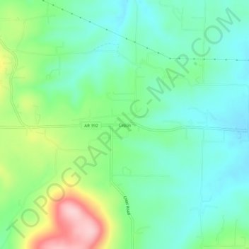
Nom : Carte topographique Capps, altitude, relief.
Lieu : Capps, Boone County, Arkansas, United States (36.21563 -93.20935 36.25563 -93.16935)
Altitude moyenne : 434 m
Altitude minimum : 373 m
Altitude maximum : 579 m
Autres cartes topographiques
Cliquez sur une carte pour visualiser sa topographie, son altitude et son relief.
Olvey
United States > Arkansas > Boone County
Olvey, Boone County, Arkansas, United States
Altitude moyenne : 338 m
Omaha
United States > Arkansas > Boone County
Omaha, Boone County, Arkansas, 72662, United States
Altitude moyenne : 390 m
Valley Springs
United States > Arkansas > Boone County
Valley Springs, Boone County, Arkansas, 72601, United States
Altitude moyenne : 345 m
Batavia
United States > Arkansas > Boone County
Batavia, Boone County, Arkansas, United States
Altitude moyenne : 455 m
Diamond City
United States > Arkansas > Boone County
Diamond City, Boone County, Arkansas, 72630, United States
Altitude moyenne : 223 m
Zinc
United States > Arkansas > Boone County
Zinc, Boone County, Arkansas, 72601, United States
Altitude moyenne : 324 m
Bellefonte
United States > Arkansas > Boone County
Bellefonte, Boone County, Arkansas, 72601, United States
Altitude moyenne : 340 m
South Lead Hill
United States > Arkansas > Boone County
South Lead Hill, Boone County, Arkansas, 72644, United States
Altitude moyenne : 243 m
Bergman
United States > Arkansas > Boone County
Bergman, Boone County, Arkansas, 72601, United States
Altitude moyenne : 384 m
Alpena
United States > Arkansas > Boone County
Alpena, Boone County, Arkansas, 72611, United States
Altitude moyenne : 373 m
Everton
United States > Arkansas > Boone County
Everton, Boone County, Arkansas, 72633, United States
Altitude moyenne : 292 m
Lead Hill
United States > Arkansas > Boone County
Lead Hill, Boone County, Arkansas, United States
Altitude moyenne : 306 m
Harrison
United States > Arkansas > Boone County
Harrison, Boone County, Arkansas, 72601, United States
Altitude moyenne : 371 m