
Carte topographique Lake
Carte interactive
Cliquez sur la carte pour afficher l’altitude.
À propos de cette carte
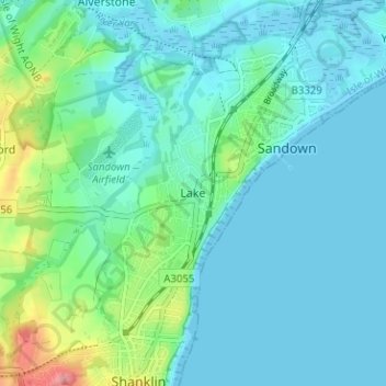
Nom : Carte topographique Lake, altitude, relief.
Altitude moyenne : 17 m
Altitude minimum : -2 m
Altitude maximum : 87 m
Lake is a seaside village situated above the cliffs on Sandown bay, it stands at an elevation of 63 feet (19 m) above sea-level. Lake's beach or 'Welcome Beach' has golden sands and reached by a steep path down the sandstone cliffs to the Revetment. It has two cafes (Hinks and Strollers), beach huts, a Sea Scout hut and inshore lifeboat.