Géolocaliser

Carte topographique Ormiston

Cliquez sur la carte pour afficher l’altitude.

Ormiston

Ormiston is a village in East Lothian, Scotland, near Tranent, Humbie, Pencaitland and Cranston, located on the north bank of the River Tyne at an elevation of about 276 feet (84 m).

Wikipedia (CC-BY-SA 3.0)

À propos de cette carte

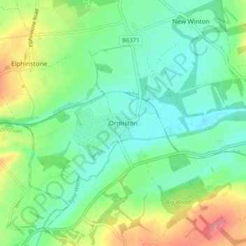
Nom : Carte topographique Ormiston, altitude, relief.

Lieu : Ormiston, East Lothian, Scotland, EH35 5HT, United Kingdom (55.89285 -2.95984 55.93285 -2.91984)

Altitude moyenne : 102 m

Altitude minimum : 75 m

Altitude maximum : 159 m

Autres cartes topographiques

Cliquez sur une carte pour visualiser sa topographie, son altitude et son relief.

Bass Rock

United Kingdom > Scotland > East Lothian

Altitude moyenne : 0 m

Firth of Forth

United Kingdom > Scotland > East Lothian

Altitude moyenne : 87 m

Lammermuirs

United Kingdom > Scotland > East Lothian

Altitude moyenne : 266 m

River Esk

United Kingdom > Scotland > East Lothian > Musselburgh

Altitude moyenne : 7 m

Coldale Wood

United Kingdom > Scotland > East Lothian

Altitude moyenne : 65 m

Équipez-vous pour votre prochaine aventure :

🧤Sous-Gants en Soie - Apport de chaleur supplémentaire ultra-léger.
🧢Casquette de Trail - Respirabilité maximale pour les activités intenses.
🔪Couteau de Poche - L'outil indispensable pour toutes les situations en extérieur.
🎒Sac à Dos de Jour - Sacs ergonomiques pour vos sorties à la journée ou le weekend.
🧼Serviette Microfibre - Séchage rapide et encombrement minimal.

En tant que Partenaire Amazon, ce site perçoit une commission sur les achats éligibles sans surcoût pour vous.