
Carte topographique Khohi Kaman
Carte interactive
Cliquez sur la carte pour afficher l’altitude.
À propos de cette carte
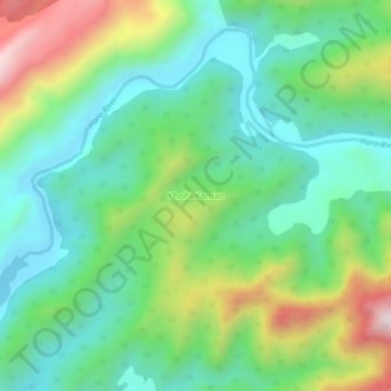
Nom : Carte topographique Khohi Kaman, altitude, relief.
Altitude moyenne : 825 m
Altitude minimum : 596 m
Altitude maximum : 1 328 m
Autres cartes topographiques
Cliquez sur une carte pour visualiser sa topographie, son altitude et son relief.
Kohala Bala
Pakistan > Khyber Pakhtunkhwa > Haripur District
Kohala Bala, Khanpur Tehsil, Haripur District, Hazara Division, Khyber Pakhtunkhwa, Pakistan
Altitude moyenne : 997 m