Géolocaliser

Carte topographique 生米村

Carte interactive

Cliquez sur la carte pour afficher l’altitude.

À propos de cette carte

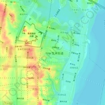
Nom : Carte topographique 生米村, altitude, relief.

Lieu : 生米村, 红谷滩区, 南昌市, 江西省, 中国 (28.55354 115.77061 28.59354 115.81061)

Altitude moyenne : 31 m

Altitude minimum : 11 m

Altitude maximum : 69 m

Autres cartes topographiques

Cliquez sur une carte pour visualiser sa topographie, son altitude et son relief.

山图村

中国 > 江西省 > 红谷滩区

山图村, 红谷滩区, 南昌市, 江西省, 中国

Altitude moyenne : 44 m

北坊

中国 > 江西省 > 红谷滩区 > 厚田乡

北坊, 厚田乡, 红谷滩区, 南昌市, 江西省, 中国

Altitude moyenne : 28 m

长桶村

中国 > 江西省 > 红谷滩区

长桶村, 红谷滩区, 南昌市, 江西省, 330063, 中国

Altitude moyenne : 30 m

雅瑶村

中国 > 江西省 > 红谷滩区 > 渔业村

雅瑶村, 九龙湖街道, 渔业村, 红谷滩区, 南昌市, 江西省, 中国

Altitude moyenne : 22 m

岭口村

中国 > 江西省 > 红谷滩区

岭口村, 红谷滩区, 南昌市, 江西省, 330038, 中国

Altitude moyenne : 21 m

卫东街道

中国 > 江西省 > 红谷滩区 > 渔业村

卫东街道, 渔业村, 红谷滩区, 南昌市, 江西省, 中国

Altitude moyenne : 22 m