
Faire un don
Équipez-vous pour votre prochaine aventure :
En tant que Partenaire Amazon, ce site perçoit une commission sur les achats éligibles sans surcoût pour vous.
Carte topographique Downsville
Cliquez sur la carte pour afficher l’altitude.
Faire un don
Équipez-vous pour votre prochaine aventure :
En tant que Partenaire Amazon, ce site perçoit une commission sur les achats éligibles sans surcoût pour vous.
À propos de cette carte
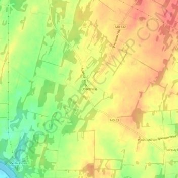
Nom : Carte topographique Downsville, altitude, relief.
Altitude moyenne : 141 m
Altitude minimum : 102 m
Altitude maximum : 168 m
Faire un don
Équipez-vous pour votre prochaine aventure :
En tant que Partenaire Amazon, ce site perçoit une commission sur les achats éligibles sans surcoût pour vous.
Autres cartes topographiques
Cliquez sur une carte pour visualiser sa topographie, son altitude et son relief.
Hagerstown
United States > Maryland > Washington County
Hagerstown has a distinct topography, formed by stone ridges running from northeast to southwest through the center of town. Geography accordingly bounds its neighborhoods. These ridges consist of upper Stonehenge limestone. Many of the older buildings were built from this stone, which is easily quarried and…
Altitude moyenne : 170 m
Faire un don
Équipez-vous pour votre prochaine aventure :
En tant que Partenaire Amazon, ce site perçoit une commission sur les achats éligibles sans surcoût pour vous.
Antietam National Battlefield
United States > Maryland > Washington County > Sharpsburg
Altitude moyenne : 147 m
Faire un don
Équipez-vous pour votre prochaine aventure :
En tant que Partenaire Amazon, ce site perçoit une commission sur les achats éligibles sans surcoût pour vous.
Hagerstown
United States > Maryland > Washington County
Hagerstown has a distinct topography, formed by stone ridges running from northeast to southwest through the center of town. Geography accordingly bounds its neighborhoods. These ridges consist of upper Stonehenge Limestone. Many of the older buildings were built from this stone, which is easily quarried and…
Altitude moyenne : 170 m
South Mountain State Park
United States > Maryland > Washington County > Mount Lena
Altitude moyenne : 201 m
Faire un don
Équipez-vous pour votre prochaine aventure :
En tant que Partenaire Amazon, ce site perçoit une commission sur les achats éligibles sans surcoût pour vous.
Hagerstown
United States > Maryland > Washington County
Hagerstown has a distinct topography, formed by stone ridges running from northeast to southwest through the center of town. Geography accordingly bounds its neighborhoods. These ridges consist of upper Stonehenge Limestone. Many of the older buildings were built from this stone, which is easily quarried and…
Altitude moyenne : 170 m
Faire un don
Équipez-vous pour votre prochaine aventure :
En tant que Partenaire Amazon, ce site perçoit une commission sur les achats éligibles sans surcoût pour vous.