
Faire un don
Équipez-vous pour votre prochaine aventure :
En tant que Partenaire Amazon, ce site perçoit une commission sur les achats éligibles sans surcoût pour vous.
Carte topographique Mount McKinley
Cliquez sur la carte pour afficher l’altitude.
Faire un don
Équipez-vous pour votre prochaine aventure :
En tant que Partenaire Amazon, ce site perçoit une commission sur les achats éligibles sans surcoût pour vous.
À propos de cette carte
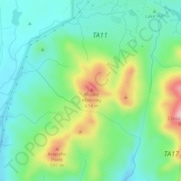
Nom : Carte topographique Mount McKinley, altitude, relief.
Lieu : Mount McKinley, Comanche County, Oklahoma, United States (34.69488 -98.61162 34.69498 -98.61152)
Altitude moyenne : 498 m
Altitude minimum : 429 m
Altitude maximum : 652 m
Faire un don
Équipez-vous pour votre prochaine aventure :
En tant que Partenaire Amazon, ce site perçoit une commission sur les achats éligibles sans surcoût pour vous.
Autres cartes topographiques
Cliquez sur une carte pour visualiser sa topographie, son altitude et son relief.
Lawton
United States > Oklahoma > Comanche County
Developed on former reservation lands of the Kiowa, Comanche, and Apache Indians, Lawton was founded by European Americans on 6 August 1901. It was named after Major General Henry Ware Lawton, who served in the Civil War, where he earned the Medal of Honor, and was killed in action in the Philippine–American…
Altitude moyenne : 352 m
Medicine Bluffs
United States > Oklahoma > Comanche County > Lawton > White Wolf Bridge
Altitude moyenne : 363 m
Faire un don
Équipez-vous pour votre prochaine aventure :
En tant que Partenaire Amazon, ce site perçoit une commission sur les achats éligibles sans surcoût pour vous.
Wichita Mountains National Wildlife Refuge
United States > Oklahoma > Comanche County > Medicine Park
Altitude moyenne : 498 m
Faire un don
Équipez-vous pour votre prochaine aventure :
En tant que Partenaire Amazon, ce site perçoit une commission sur les achats éligibles sans surcoût pour vous.
Lawton
United States > Oklahoma > Comanche County
Developed on former reservation lands of the Kiowa, Comanche, and Apache peoples, Lawton was incorporated in 1901. It was named after Major General Henry Ware Lawton, who served in the Civil War, where he earned the Medal of Honor, and was killed in action in the Philippine–American War. Lawton's landscape…
Altitude moyenne : 352 m
Faire un don
Équipez-vous pour votre prochaine aventure :
En tant que Partenaire Amazon, ce site perçoit une commission sur les achats éligibles sans surcoût pour vous.